Trio of tropical threats emerge in Atlantic as peak of hurricane season nears
The National Hurricane Center highlighted a new area of concern in the central Atlantic Ocean on Tuesday morning. That is being monitored for development, in addition to two other disturbances across the Atlantic Ocean and Caribbean Sea.

Trio of tropical threats monitored in the Caribbean and Atlantic
FOX Weather Hurricane Specialist Bryan Norcross gives an update on the three tropical disturbances monitored in the Atlantic and Caribbean and delves into when will the hurricane season return to life?
MIAMI – We’re just days away from the statistical peak of the 2024 Atlantic hurricane season, and right on schedule, things are starting to heat up as a third area of disturbed weather is being monitored by the National Hurricane Center (NHC).

The tropical weather outlook for the Atlantic Ocean.
(FOX Weather)
This new area popped up as forecasters dropped development chances for an area of showers and thunderstorms spinning off the coasts of Texas and Louisiana in the Gulf of Mexico that has funneled heavy precipitation into the region.
But now attention has turned to tropical disturbances that have spun up in the Caribbean, as well as the central and eastern Atlantic Ocean. Though the NHC has now placed all three disturbances with only a "low" chance for further development as of their Tuesday afternoon tropics forecast update.
The increase in tropical activity comes amid an eerily quiet period in the Atlantic. There hasn't been a named storm in the Atlantic since Ernesto on Aug. 12.
"The last time that the Atlantic had no named storm formations between August 13-September 3 was in 1968," Phil Klotzbach, a senior research scientist at Colorado State University, said in a post on X, formerly Twitter. "The remarkable quiet period for the Atlantic hurricane activity continues."
DOWNLOAD THE FREE FOX WEATHER APP
Caribbean disturbance could eventually develop into tropical depression
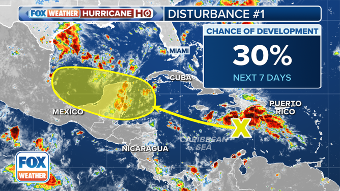
The outlook for a tropical disturbance in the Atlantic Ocean.
(FOX Weather)
The first area of concern is located in the Caribbean, where disorganized showers and thunderstorms continue to bubble up as the system continues on its westward journey across the region.
The NHC said environmental conditions are expected to become more conducive for development when the system reaches the western Caribbean and southwestern Gulf of Mexico later this week and into the weekend, and a tropical depression could form at that time.
But confidence dipped a bit on Tuesday afternoon, and forecasters are now giving the system a 30% chance of developing over the next seven days - a drop of 10% from Tuesday morning's forecast.
Disturbance in eastern tropical Atlantic has low chance of developing
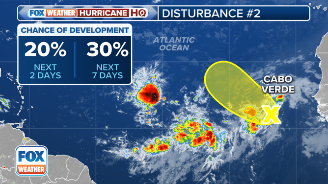
The outlook for a tropical disturbance in the Atlantic Ocean.
(FOX Weather)
Confidence for development also dipped slightly for a tropical disturbance over the far eastern Atlantic Ocean, which is producing an area of disorganized showers and thunderstorms. The NHC says environmental conditions are expected to become a little more conducive for slow development over the next few days. That system, the NHC said, could produce locally heavy rain and strong winds across portions of the Cabo Verde Islands in a few days.
But now NHC forecasters say newest data shows conditions will likely become less conducive for development by the end of the week, and they have trimmed 10% off the development odds for this disturbance too, dropping from 40% to 30% over the next week.
New area forms in central Atlantic
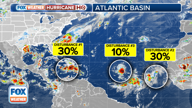
Areas to Watch in Tropical Atlantic.
(FOX Weather)
The NHC highlighted a new area of concern in the central Atlantic Ocean on Tuesday morning.
The NHC said the tropical disturbance is located about halfway between the west coast of Africa and the Lesser Antilles and is producing disorganized showers and thunderstorms.
Some slow development is possible over the next few days while the system moves off to the west-northwest. By the end of the week, however, environmental conditions are expected to become unfavorable for additional development.
The NHC is giving the system a low chance of developing over the next seven days.