From quiet beginnings to a cluster of tropical disturbances: Eastern Pacific erupts with activity
Tropical Storm Carlotta formed in the Eastern Pacific on Wednesday, but there are also two other tropical disturbances being tracked.

Tracking Tropical Storm Carlotta and future Daniel in the eastern Pacific
The FOX Forecast Center expects at least two new cyclones will form during the next couple of weeks in the eastern Pacific.
Through the first two and a half months of the hurricane season, the Eastern Pacific only produced two tropical storms. However, a series of systems in the basin have the potential to double season activity.
The National Hurricane Center is closely monitoring three areas of disturbed weather in the Eastern Pacific, with the formation of Carlotta on Wednesday and Daniel expected over the next week.
A tropical cyclone is given a name when sustained winds reach at least 39 mph around a center of low pressure.
Aletta and Bud only reached minimal tropical storm strength in the basin, but Carlotta could be the first cyclone to reach hurricane status in the Eastern Pacific during the 2024 season.
According to the FOX Forecast Center, low vertical wind shear and warm sea-surface temperatures would likely result in the cyclone reaching at least Category 2 status. Some forecast models even suggest that a major hurricane is not out of the realm of possibility.
Neither Carlotta nor the future Daniel are expected to pose a direct threat to land, but increased wave action is anticipated along the coast of Mexico.
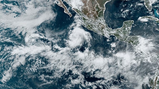
Tracking the tropics in the eastern Pacific.
(NOAA)
A LOOK AT HOW ACTIVE THE HURRICANE SEASON COULD BE IN THE EASTERN PACIFIC
Eastern Pacific far behind normal
By the first day of August, a typical season in the Eastern Pacific produces five named storms, three hurricanes and one becoming a major cyclone with winds of at least 115 mph.
So far, only three named storms have formed, which has produced a measly Accumulated Cyclone Energy value of 1.8 units.
The value is more than 95% below the typical value of 42.3 units, which is the average year-to-date value.
Before the season began, Mexico’s national weather service expected 15-18 named storms to form, with 7-9 becoming hurricanes and 3-4 strengthening into major hurricanes.
One of the many factors that could be weighing down activity is the status of the El Niño–Southern Oscillation climate pattern or what is commonly referred to as ENSO for short.
The ENSO currently sits in a neutral stage with computer models showing the entrance into a La Niña state by the end of 2024.
A La Niña pattern results in cooler water and more hostile upper-level winds in the Eastern and Central Pacific.
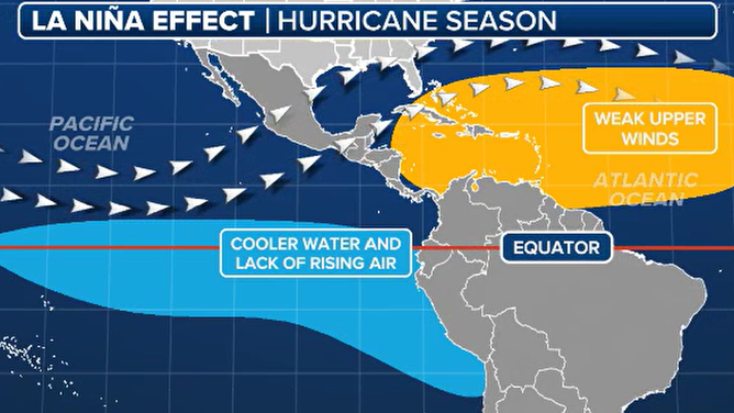
La Niña hurricane season impacts.
(FOX Weather)
What is causing the recent uptick in activity?
A feature known as the Madden-Julian Oscillation, otherwise known as the MJO, is largely credited for being responsible for the increase in activity.
The MJO is an eastward traveling pulse of lift and enhanced moisture that impacts areas along the equator and the subtropics.
This upward motion is just now entering the eastern Pacific, so for the next several days to few weeks, activity in the basin could be on the increase, compared to its inactive state.
It is during this phase that the Atlantic and other parts of the globe are typically shut down for tropical cyclone formation, as drier, sinking air takes hold.
It is estimated that any one particular point within the MJO takes 30-60 days to circle the globe, so that could align with the Atlantic seeing the potential for an increase in tropical cyclone activity later in August.
(FOX Weather)