Budding tropical threat in Caribbean, Gulf of Mexico sorts into these 4 scenarios
A number of computer forecast models depict a strong tropical storm or hurricane in the Gulf of Mexico by the end of next week, but there still remains a lot of uncertainty in the forecast with several potential outcomes.

Four scenarios in play for how tropical activity may progress through next week
All eyes remain on the Caribbean and Gulf of Mexico where there are growing signs there may be tropical development in the area. The FOX Weather team breaks down what Mother Nature may have up her sleeve.
The next tropical threat to the U.S. is brewing in the Caribbean as there are increasing signs that the ingredients needed for a tropical storm or even a hurricane are coming together.
A number of computer forecast models depict a strong tropical storm or hurricane in the Gulf of Mexico by the end of next week, but there still remains a lot of uncertainty in the forecast, with several potential outcomes.
The National Hurricane Center currently gives high odds of tropical development in the western Caribbean Sea or southern Gulf of Mexico within the next seven days. The odds have been steadily increasing over the past week, and further development may loom beyond seven days as the development window gets closer, according to the FOX Forecast Center.

(FOX Weather)
"From Texas to Florida, the entire Gulf Coast is still at play," said FOX Weather Meteorologist Stephen Morgan.
Building a weather puzzle
Pieces of the puzzle are going to be slow to come together.
There are strong indications a weather pattern known as the Central American Gyre will form in the coming days.
The gyre is a sprawling area of low pressure that feeds off moisture streaming in from the Pacific Ocean and forms near or over Central America. At its core, it is a heavy rain producer with impacts extending outwards hundreds of miles and leading to threats of torrential rainfall, flooding and landslides for more than a dozen countries centered in and around Central America.

(FOX Weather)
WHAT IS THE CENTRAL AMERICAN GYRE?
However, organized low-pressure centers can develop into tropical storms or even hurricanes within the larger gyre if water temperatures and upper-level winds become favorable for tropical development. Current water temperatures in the Caribbean are near the record-warm levels set last season.
The ultimate fate of tropical development will depend on where the gyre forms, how strong it becomes and the atmospheric steering - or blocking - patterns occurring in the southern U.S.
There are four main scenarios with how the forecast will shake out, each successive one presenting a greater threat to the U.S. Gulf Coast.
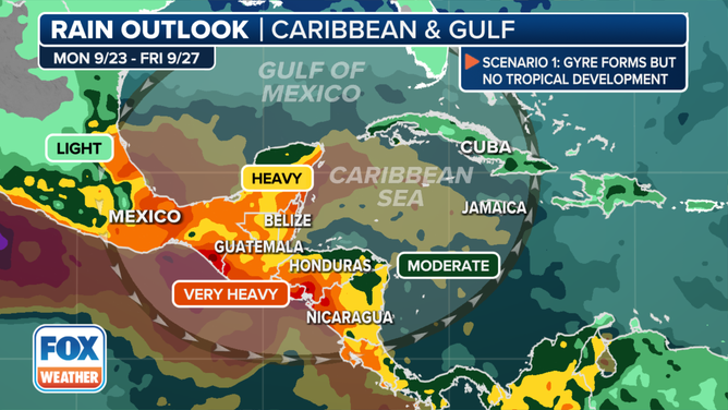
Tropical threat scenario 1: Gyre forms but no tropical development
(FOX Weather)
In this case, the atmospheric conditions come together for the broad area of low pressure to bring rain to Central America, but the right conditions to create any individual low-pressure areas never materialize.
"This being the least impactful to the U.S. mainland, (but) that doesn't speak anything to what we could see in Central America," Morgan said. "The gyre also produces prolific amounts of rain, so we're expecting heavy rain from Belize, Guatemala to Honduras, as far south as Panama, Mexico, to going to deal with just the rain."
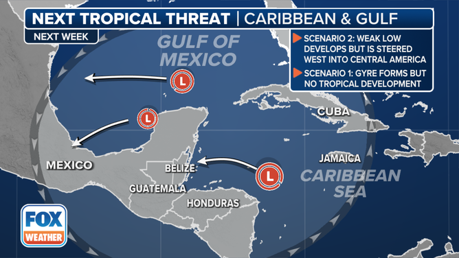
Tropical threat scenario 2: Weak low develops, but is steered west into Central America
(FOX Weather)
If low pressure centers form on the northern and western edge of the gyre, and if high pressure becomes entrenched over the southern U.S., that would create a block across the Gulf and instead steer storms into Central America.
"So that could lead to rounds of heavy rain (there)," Morgan said. "That could also cause some concerns in regards to mudslides, and landslides."
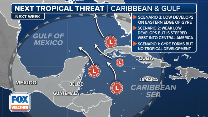
Tropical threat scenario 3: Low develops on the eastern side of the gyre, but in the Caribbean
(FOX Weather)
In this case, a low-pressure center could form on the eastern side of the gyre but would develop farther south in the Caribbean.
A cyclone could still eventually move into the Gulf of Mexico and threaten coastal areas.
"Another steering mechanism that we are looking at very carefully, the potential impacts that could be associated with it would be a dip in the jet stream," said FOX Weather Meteorologist Kendall Smith. "And if that is over the eastern U.S., perhaps that tugs this system a little further to the north, and that would be more of a concern for folks living right along the Gulf Coast."
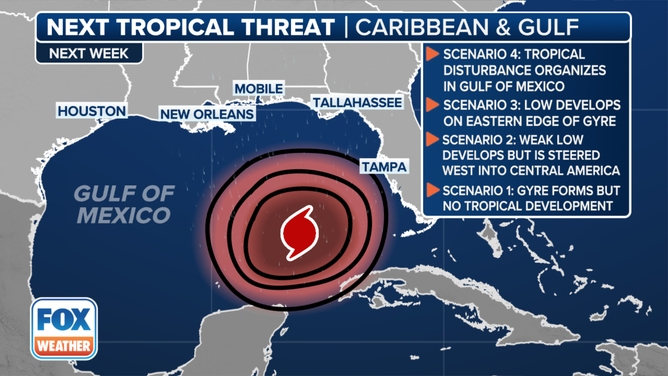
Tropical threat scenario 4: Tropical disturbance organizes in the Gulf of Mexico
(FOX Weather)
The most daunting scenario is if a low originates already in the Gulf of Mexico and then uses the record warm water temperatures to rapidly develop into a hurricane.
Forecasts for just-developing or disorganized systems are subject to large errors and significant changes.
"The computer forecasts that predict development will occur over the warm waters of the Caribbean or the extreme southeastern Gulf show a tropical storm or hurricane moving north that could affect the Gulf Coast somewhere between Louisiana and Florida late next week," said FOX Weather Hurricane Specialist Bryan Norcross. "Computer projections that develop the system over land or predict it will stay weak for longer stall it closer to Mexico. They let it drift in the western Gulf, blocked by the high to the north. It could still impact the Gulf Coast in some way, though it would seemingly take longer to develop, pushing the threat farther into the future."

Bryan Norcross goes into deeper analysis on tropical threat brewing in the Caribbean
The upper-level weather pattern is forecast to be conducive for tropical development over Central America and the surrounding waters next week.
We're still in the heart of hurricane season, so an organized tropical system is not unexpected. The western Caribbean and southern Gulf are always prime locations for tropical development in late September.
"This is a thing where everybody needs to have a little patience because nothing is going to develop quickly," Norcross said. "We’re talking about the end of next week, and everyone from Texas to Florida needs to watch this and be informed and see how it develops."