Tracking the tropics: What Invest 95L in the Gulf means for Texas
A tropical depression could form before the system moves inland over Texas later Thursday
Chances of tropical development in Gulf decrease, threats remain
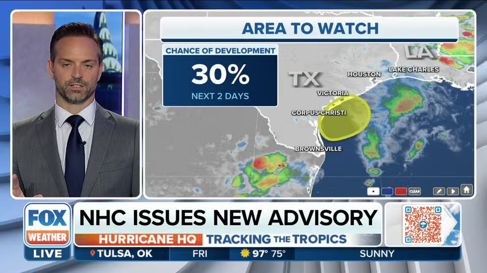
The National Hurricane Center says the tropical disturbance in the Gulf of Mexico now has a 30 percent chance of development
HOUSTON – A tropical disturbance in the northwestern Gulf of Mexico is moving ashore over Texas, ending the chances the system develops into tropical cyclone, but even with the lack of development parts of the state won't escape its impacts.
The system identified as Invest 95L is producing squally weather along the coast, which means heavy rains and rough waves and seas are to be expected between Corpus Christi, Texas and southwestern Louisiana.
An invest is simply a naming convention used by the NHC to identify an area of weather that it is investigating for possible development into a tropical depression or tropical storm within the next five days.
WHAT IS AN INVEST DURING HURRICANE SEASON?

(FOX Weather)
A Hurricane Hunter aircraft flew into the disturbance on Thursday and determined the system had not organized into a tropical depression.
HOW TO WATCH FOX WEATHER ON TV
The threat of high surf and rip currents will begin to diminish on Saturday as the tropical disturbance moves farther inland in Texas.

Hurricane Hunters fly through tropical disturbance off the coast of Texas
Hurricane Hunters flew through 95L off the coast Texas to determine if the system was organizing into a tropical cyclone.
Flood threat
Over the next few days, the upper Texas coast and southwestern Louisiana could see several inches of rain from the slow-moving tropical disturbance.
Forecast models show at least 3 to 5 inches of rain is expected to fall with some locally higher amounts, especially south and east of Houston.
CLICK HERE TO GET THE FOX WEATHER UPDATE PODCAST

(FOX Weather)
The National Weather Service has issued a Flood Watch for portions of southeastern Texas, including Houston and Galveston, through Friday evening. The highest flooding concerns will be along the immediate coast before expanding across the rest of the Flood Watch area into Friday.
7 FACTS YOU SHOULD KNOW ABOUT FLASH FLOODS

(FOX Weather)
Rainfall is welcome news
More than 85% of Texas is in some sort of drought, so the potential for heavy rainfall is welcome news in the Lone Star State.
The ongoing drought is even considered to be "exceptional" – the worst category on the U.S. Drought Monitor – in nearly 16% of Texas, which increases the risk for fires and leads to water shortages.
THE U.S. DROUGHT MONITOR EXPLAINED
Galveston is more than 8 inches of rainfall below average for the year, and communities in the central and western parts of the state are in even worse shape.

(FOX Weather)
San Antonio has a rainfall deficit of nearly 11 inches for the year, and homeowners and businesses are dealing with water restrictions.
The tropical disturbance’s heaviest rainfall will likely remain east of Interstate 35 and should taper off as the system works northward through the state over the Fourth of July weekend.
HOUSTON, WE HAVE A PROBLEM: NATION’S 4TH LARGEST CITY ASKS RESIDENTS TO CUT BACK ON WATER USAGE
Tropics busy elsewhere
Elsewhere in the tropics, meteorologists are monitoring Potential Tropical Cyclone Two speeding across the Caribbean.
Forecasters say there is around a 90% chance the tropical disturbance could develop into at least a tropical storm before reaching Central America this weekend.

(FOX Weather)
Computer forecast models show the potential tropical cyclone staying on a southern trajectory through the Caribbean and never becoming a threat to the U.S. mainland.
WHAT IS A POTENTIAL TROPICAL CYCLONE?
The next name on the list of storms in the Atlantic Basin is "Bonnie."
During an average season, the second named storm forms around July 17.
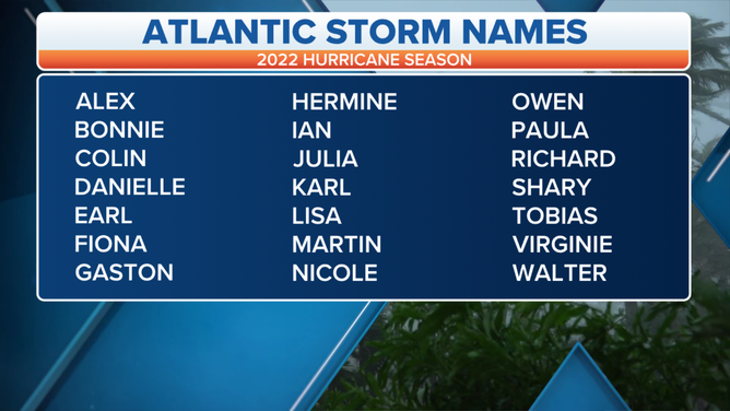
A table showing an alphabetical list of the 2022 Atlantic tropical cyclone names as selected by the World Meteorological Organization. The official Atlantic hurricane season runs from June 1 through Nov. 30.
(FOX Weather)
Be sure to download the FOX Weather app to track any storms in your area and receive potentially life-saving weather alerts issued by the National Weather Service. The free FOX Weather livestream is also available 24/7 on the website and app and on your favorite streaming platform. The FOX Weather Update podcast also provides weather information for the entire country.