Tropical trouble may be brewing again for the final month of hurricane season
There are growing signs of favorable development of a tropical cyclone somewhere in the Caribbean around the start of November.
Confidence in possible tropical trouble in Atlantic growing
Forecasters are closely watching the Caribbean Sea as confidence grows that a tropical system will develop in the region. Where it ultimately goes is still unclear.
The National Hurricane Center is tracking an area of disturbed weather that has a 30% chance of developing into a cyclone over the next week deep in the Caribbean Sea.
Currently, the atmospheric pattern has a lot of sinking air over the Caribbean and Gulf of Mexico, which inhibits tropical development. But the long-range prospects of the Madden-Julian oscillation — a global pattern that cycles areas of rising and sinking air every 30-90 days — suggests rising air will return to the Caribbean in early November.

(FOX Weather)
That would coincide with the return of the Central American Gyre — which had a hand in creating Hurricanes Helene and Milton, and more recently, Tropical Storm Nadine.
Most of the time, these cyclones aren’t a threat to the Lower 48, but occasionally, a storm system can come out of the deep tropics and impact Florida or provide a glancing blow to the Eastern Seaboard.
WHAT IS THE CENTRAL AMERICAN GYRE?
Gulf of Mexico waters finally cool off
There was some good tropical news to emerge this week in the Gulf of Mexico.
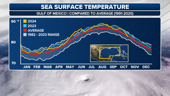
For the first time in more than a year, the average Gulf water temperature has dipped below average, thanks to a combination of cold fronts, persistent winds, and the churning effects of Hurricanes Milton and Helene.

(FOX Weather)
The last time temperatures were average was June 2023. However, they still currently average around 81 degrees overall - still plenty warm for tropical development.
Water temperatures in the Caribbean remain at near record levels and well into the mid-80s, which is sufficient for tropical cyclone formation.
The hurricane season in the Atlantic basin runs through November 30.
