Hurricane Milton spawns deadly tornado outbreak in South Florida: 'Hundreds of homes' destroyed
One of the hardest-hit areas was St. Lucie County in Southeast Florida. The St. Lucie County Emergency Operations Center has confirmed to FOX Weather that at least four people were killed during Wednesday's tornadoes.

Dangerous tornado from outer bands of Hurricane Milton seen in Clewiston, Florida
A dangerous tornado was seen in Clewiston, Florida, on Wednesday morning as outer bands of Hurricane Milton impact the state ahead of landfall.
WEST PALM BEACH, Fla. – A deadly tornado outbreak slammed a wide swath of Florida Wednesday as the powerful outer bands of Hurricane Milton tapped into atmospheric conditions that became conducive for severe weather.
One of the hardest-hit areas was St. Lucie County in Southeast Florida. The St. Lucie County Emergency Operations Center confirmed to FOX Weather that at least four people were killed during Wednesday's tornadoes.
St. Lucie County Sheriff Keith Pearson said the victims were in Spanish Lakes Country Club Village in northern Fort Pierce, where a significant tornado moved through on Wednesday.
"The most impacted area is about a half-square-mile community made up of older modular homes that the tornado went through and just completely devastated it," Pearson told FOX Weather. "They don't even look like homes anymore. They're mangled there. There's people trapped underneath them."

Hurricane Milton leaves at least 4 dead in St. Lucie County, Florida
A tornado outbreak spawned by Hurricane Milton is being blamed for the deaths of at least four people in St. Lucie County, Florida. St. Lucie County Sheriff Keith Pearson said the victims were in Spanish Lakes Country Club Village in northern Fort Pierce, where a significant tornado moved through on Wednesday.
On Wednesday morning, stunning video from Florida Department of Transportation cameras along Interstate 75 in Alligator Alley between Broward and Palm Beach counties captured the destructive force of Milton's extreme weather in the state. It was the second tornado in less than 20 minutes that was witnessed as these storms lifted north.

Florida's I-75 hit by tornado Wednesday as outer bands of Milton arrive
Outer bands of Hurricane Milton are already impacting Florida ahead of landfall, bringing heavy rainfall, strong winds and tornadoes.
Tornadoes were spotted in Fort Pierce and Vero Beach, including one near the Florida Turnpike west of Fort Pierce.
Additional video footage captured the large tornado near the Miccosukee Service Plaza west of Andytown. The tornado was associated with a tornado-warned supercell thunderstorm.
Another video recorded in Clewiston, Florida, shows a tornado spinning across the landscape on Wednesday morning.

Watch: Tornado rips across Clewiston area as Milton starts to lash Florida ahead of landfall
A video recorded in Clewiston, Florida, shows a tornado spinning across the landscape as the first impacts from Hurricane Milton arrive in the state ahead of its anticipated catastrophic landfall later on Wednesday night.
Photos in West Palm Beach show extensive damage to a neighborhood from a possible tornado, including a dumpster on top of a home.
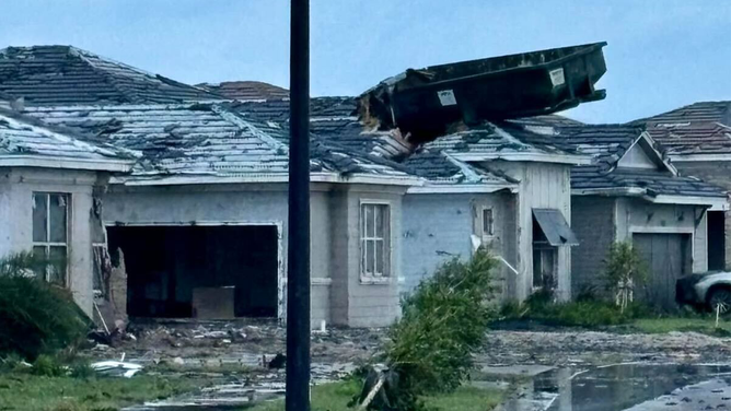
Possible tornado damage in West Palm, Florida after Hurricane Milton's outer bands spawned a tornado outbreak on Oct. 9, 2024.
(Jill Cohen)
The National Weather Service gave that tornado a preliminary rating of EF-3, but there is still plenty more to investigate about this tornado.
"This tornado had a relatively long track and this preliminary rating was based on just one neighborhood which was also one of the hardest hit," NWS Miami said. "This will likely require a multi-day survey to obtain the complete picture and assign a final rating."
![]() Image 1 of 10
Image 1 of 10PORT ST LUCIE, FLORIDA - OCTOBER 10: The inside of a mini mart of a local gas station is left damaged by a tornado caused by Hurricane Milton, on October 10, 2024 in Port St Lucie, Florida. The storm made landfall as a Category 3 hurricane in the Siesta Key area of Florida, causing damage and flooding throughout Central Florida. (Photo by Saul Martinez/Getty Images) ( )
![]() Image 2 of 10
Image 2 of 10PORT ST LUCIE, FLORIDA - OCTOBER 10: The inside of a mini mart of a local gas station is left damaged by a tornado caused by Hurricane Milton, on October 10, 2024 in Port St Lucie, Florida. The storm made landfall as a Category 3 hurricane in the Siesta Key area of Florida, causing damage and flooding throughout Central Florida. (Photo by Saul Martinez/Getty Images) ( )
![]() Image 3 of 10
Image 3 of 10PORT ST LUCIE, FLORIDA - OCTOBER 10: Lakewood Park Church is left damaged by a tornado caused by Hurricane Milton, on October 10, 2024 in Port St Lucie, Florida. The storm made landfall as a Category 3 hurricane in the Siesta Key area of Florida, causing damage and flooding throughout Central Florida. (Photo by Saul Martinez/Getty Images) ( )
![]() Image 4 of 10
Image 4 of 10PORT ST LUCIE, FLORIDA - OCTOBER 10: A McDonald's sign damaged by a tornado caused by Hurricane Milton, on October 10, 2024 in Port St Lucie, Florida. The storm made landfall as a Category 3 hurricane in the Siesta Key area of Florida, causing damage and flooding throughout Central Florida. (Photo by Saul Martinez/Getty Images) ( )
![]() Image 5 of 10
Image 5 of 10PORT ST LUCIE, FLORIDA - OCTOBER 10: The inside of a mini mart of a local gas station is left damaged by a tornado caused by Hurricane Milton, on October 10, 2024 in Port St Lucie, Florida. The storm made landfall as a Category 3 hurricane in the Siesta Key area of Florida, causing damage and flooding throughout Central Florida. (Photo by Saul Martinez/Getty Images) ( )
![]() Image 6 of 10
Image 6 of 10PORT ST LUCIE, FLORIDA - OCTOBER 10: Road ways left damaged by a tornado caused by Hurricane Milton, on October 10, 2024 in Port St Lucie, Florida. The storm made landfall as a Category 3 hurricane in the Siesta Key area of Florida, causing damage and flooding throughout Central Florida. (Photo by Saul Martinez/Getty Images) ( )
![]() Image 7 of 10
Image 7 of 10PORT ST LUCIE, FLORIDA - OCTOBER 10: Homes damaged by a tornado caused by Hurricane Milton, on October 10, 2024 in Port St Lucie, Florida. The storm made landfall as a Category 3 hurricane in the Siesta Key area of Florida, causing damage and flooding throughout Central Florida. (Photo by Saul Martinez/Getty Images) ( )
![]() Image 8 of 10
Image 8 of 10PORT ST LUCIE, FLORIDA - OCTOBER 10: Road ways left damaged by a tornado caused by Hurricane Milton, on October 10, 2024 in Port St Lucie, Florida. The storm made landfall as a Category 3 hurricane in the Siesta Key area of Florida, causing damage and flooding throughout Central Florida. (Photo by Saul Martinez/Getty Images) ( )
![]() Image 9 of 10
Image 9 of 10A woman collects debris caused by the destruction of the tornado's path in Cocoa Beach, Florida,on October 10, 2024. Hurricane Milton tore a coast-to-coast path of destruction across the US state of Florida, whipping up a spate of deadly tornadoes that left at least four people dead, but avoiding the catastrophic devastation officials had feared. (Photo by GIORGIO VIERA / AFP) (Photo by GIORGIO VIERA/AFP via Getty Images) ( )
![]() Image 10 of 10
Image 10 of 10A woman collects debris caused by the destruction of the tornado's path in Cocoa Beach, Florida,on October 10, 2024. Hurricane Milton tore a coast-to-coast path of destruction across the US state of Florida, whipping up a spate of deadly tornadoes that left at least four people dead, but avoiding the catastrophic devastation officials had feared. (Photo by GIORGIO VIERA / AFP) (Photo by GIORGIO VIERA/AFP via Getty Images) ( )


More than 125 Tornado Warnings were issued as of Wednesday evening – several of them confirmed tornado sightings.

(FOX Weather)
The NWS Miami office has broken its record for the most Tornado Warnings issued in a single day, with 55 issued Wednesday. The previous record for that office was set during Hurricane Ian.
HURRICANE MILTON SPAWNS DANGEROUS TORNADO OUTBREAK IN FLORIDA AHEAD OF CATASTROPHIC LANDFALL

Large tornado near Florida's Turnpike spotted Wednesday morning associated with Hurricane Milton
A dangerous tornado was seen near the Miccosukee Service Plaza in Ochopee, Florida. A Tornado Warning remains in effect until 10 a.m. Friday.
The FOX Forecast Center said this type of severe weather is a common threat when tropical systems make landfall.
Milton, a Category 3 hurricane made landfall along the west-central coast of Florida late Wednesday around 8:30 p.m. near Siesta Key, the National Hurricane Center said.
Milton is poised to become one of the most devastating hurricanes in U.S. history.
The storm surge associated with Milton is expected to be life-threatening and catastrophic, especially along and south of the storm's track. Additionally, the hurricane's strong winds will cause significant damage as the eyewall moves through the state. Power outages reached more than 1 million across the Sunshine State one hour after landfall.