Back-to-back storms to soak West Coast, trigger flash flood threat in Southern California
A midweek storm first drenches the Northwest, but an atmospheric river storm looms for Southern California over the weekend. Already, NOAA has placed the Los Angeles and San Diego areas in a Level 2 out of 4 flash flood threat for Saturday.
Los Angeles flood threat with second of back-to-back storms
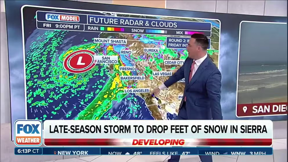
FOX Weather is tracking a second storm slamming into the West late week. Heavy rain and flooding threatens Southern California into the weekend and Northern California could see thunderstorms.
LOS ANGELES – March came in like a lion across Southern California and is set to go out in similar fashion as an atmospheric river storm aims at the region by the end of the week with the potential for flooding rain around Los Angeles and San Diego.
It’ll be the second storm to strike the West Coast this week. A first low-pressure system sends a cold front through the Pacific Northwest late Wednesday and into Thursday. Widespread rain will cover the Interstate 5 corridor, with several inches of snow in the higher elevations of the Washington Cascades and a few inches in the Oregon Cascades.
For the lowlands, Seattle in Washington and Portland in Oregon have received less than half of their average rain for March, so this rain will be welcomed and at least nudge them closer to average.
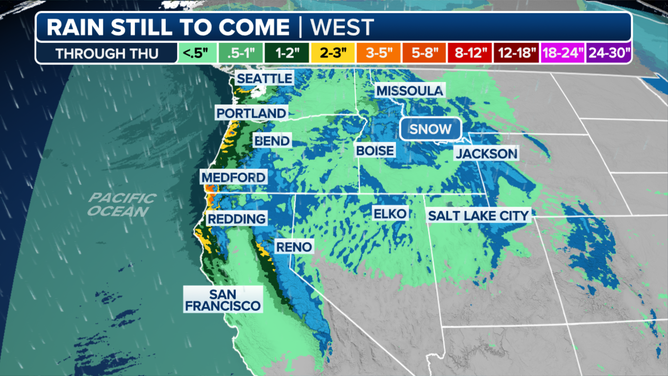
West Coast Precipitation forecast through Thursday.
(FOX Weather)
Farther south, the cold front will bring a little rain to Northern California and a moderate amount of snow to the Sierra Nevada mountain range, where Winter Storm Warnings call for 6-12 inches of snow above 4,500 feet and up to 2 feet along the highest peaks.
The rain and snow will wind down across the Northwest and northern Rockies on Thursday night.
Next up: An atmospheric river storm for California
Once that storm moves out, a strong area of low pressure will develop off the Northern California coast on Friday and spend the weekend meandering off the coast, slowly sliding south toward Los Angeles.
CALIFORNIA’S ‘ARKSTORM’: HISTORIC 1000-YEAR FLOODS OF 1861-62 FEATURED 8 WEEKS OF ATMOSPHERIC RIVERS
This storm will tap into some tropical moisture, generating an atmospheric river storm that will spin heavy rain into Central and Southern California from Friday night through the weekend.
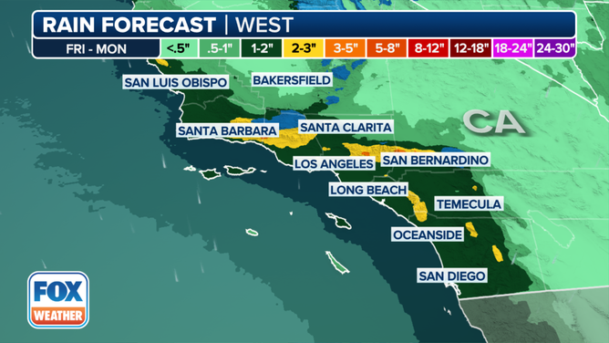
Southern California rainfall forecast for Friday through Monday morning.
(FOX Weather)
As much as 1-3 inches of rain is likely up and down coastal Southern California, including the Los Angeles Basin and San Diego area. Higher totals of 3-6 inches are likely in the foothills and mountains, with possibilities of even heavier amounts.
"(Three to 5 inches of rain) would be a concern any given day, but last weekend we had landslides in Southern California, we had flooding concerns … we’re dealing with compounded impacts here," FOX Weather Meteorologist Britta Merwin said.
Rainfall rates are forecast to reach 0.25-0.50 inches per hour across the region, with up to 0.75 inches per hour possible in locally heavier downpours. Thunderstorms are possible Saturday night, with even a low chance of severe weather.
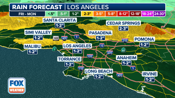
Los Angeles rainfall forecast for Friday through Monday morning.
(FOX Weather)
NOAA’s Weather Prediction Center is already placing the Santa Barbara, California, area in a Level 2 out of 4 risk for flash flooding on Friday, with that level of risk spreading across much of the Los Angeles and San Diego areas on Saturday.
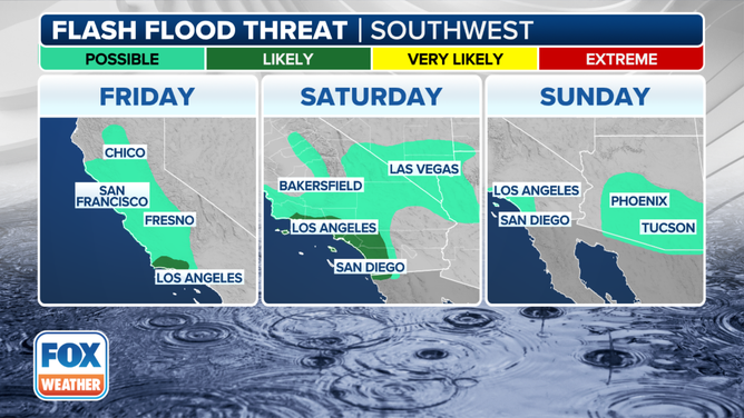
West Multi-Day Flash Flood Outlook for Friday through Sunday.
(FOX Weather)
"Take advantage (of dry weather now) if you live in Southern California," Merwin suggested. "Clear out the drainage pipes, make sure you’re good to go."
Heavy snow will fall in the higher elevations of the Southern California mountains, with 2-6 inches likely above 4,500 feet and 12-24 inches likely above 6,500 feet. There is even a low chance of snow along Interstate 5's Tejon Pass in the Grapevine.
Snow will also pile up in the Sierra Nevada, where a few feet of snow will add to the snowpack that now sits at 101% of average statewide.
'IT'S A GULLY-WASHER' AND OTHER WAYS PEOPLE SAY 'IT'S RAINING'
"This has been one of the most remarkable snowpack recoveries we have seen in modern history in California," the FOX Forecast Center said. "The statewide snowpack was a mere 28% of normal on Jan. 1 and 53% of normal on Feb. 1, before the storm train kicked into gear."
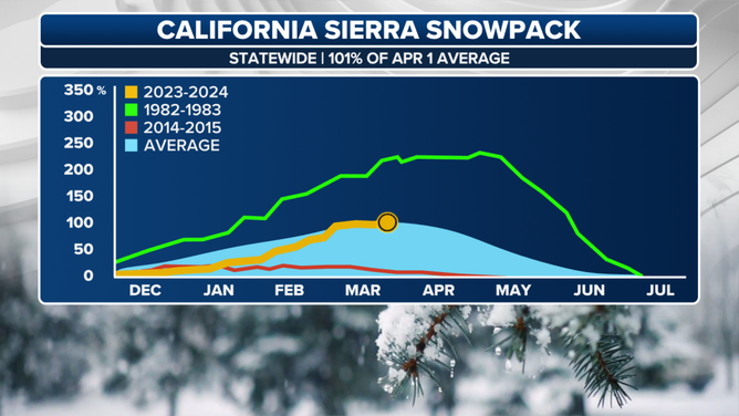
Statewide chart showing recovery of snowpack in California this year.
(FOX Weather)
Southern California is expected to dry out early next week as the storm track instead returns to the Pacific Northwest.
