Powerful windstorm may threaten March atmospheric pressure records in Midwest
A storm of that strength will result in a large and powerful wind field that could bring 50-plus-mph gusts to nearly every state east of the Rockies later Tuesday and through Wednesday, according to the FOX Forecast Center. Wind alerts are in place for nearly 16 million people, including New Orleans on Mardi Gras.

Spring storm to charge across US with damaging winds for millions
A storm moves in from the Pacific on Sunday, bringing severe weather potential this week and widespread winds. The cold-side of the storm will also bring blizzard-like conditions for the West. Wind alerts are in place for the areas east of the Rockies and the Gulf Coast, including New Orleans.
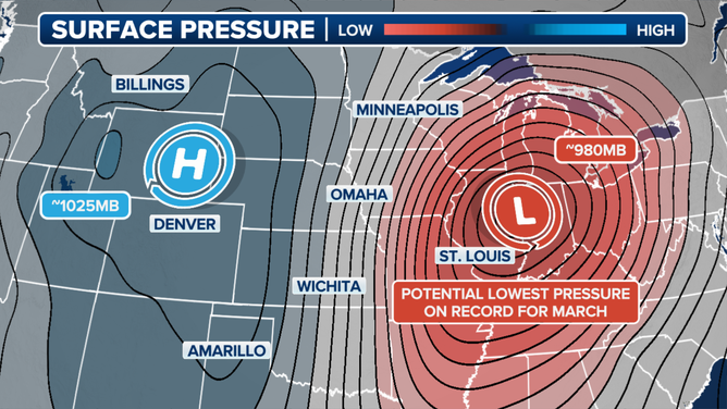
DES MOINES, Iowa – A powerful storm that is threatening a dangerous severe weather outbreak in the South Tuesday is expected to bring widespread impacts on its northern flank across the Midwest, with potentially damaging winds, soaking rain and areas of snow. The expected low-pressure area could even break some atmospheric pressure records.
The storm begins its trek across the nation Sunday when it rolls off the Pacific and spreads valley rain and mountain snow across California and into the Great Basin. Accumulation should be light with no flood concerns at this time. More than a foot of needed snow may fall high in the Sierra Nevada, where the snowpack is sitting around 85% of average.

Spring storm overview.
(FOX Weather)
The storm gathers some strength on Monday as it drops mountain snow and valley rain across the Intermountain West. Salt Lake City, which is sitting more than 30 inches below average in terms of snow, will miss out once again as temperatures in the 40s lead to cold rain. Snow is expected in Flagstaff, Arizona – the city currently with the largest snow deficit in the country at 56 inches below average – but only a few inches is expected at most.
37 MILLION FROM PLAINS TO SOUTHEAST FACE DANGEROUS SEVERE WEATHER THREAT WITH TORNADOES LIKELY
But it's as the storm emerges from the Rockies and heads into the Plains Tuesday that its impacts become more concerning. While the South deals with a potential "significant" severe weather outbreak with strong tornadoes and large hail among the primary threats, widespread damaging winds along with areas of snow and rain are likely to the north.
National Weather Service offices across the central U.S. and Gulf Coast have issued wind alerts for nearly 16 million people.
Multiple inches of snow are possible across Denver on Tuesday, though the snow forecast becomes more tricky east of Colorado due to a lack of notable cold air, the FOX Forecast Center said. But cities such as Omaha in Nebraska, Des Moines in Iowa, Chicago and Milwaukee should all be on alert for some snow as the potential is there.
(FOX Weather)
However, impactful wind gusts across several states are more certain, with the storm's central pressure expected to strengthen under 980 millibars. Such marks have the potential to set records for the lowest atmospheric pressures in March across Missouri, Illinois and Iowa.
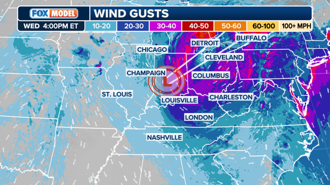
Midwest wind gust forecast on Wednesday afternoon.
A storm of that strength will result in a large and powerful wind field that could bring 50-plus-mph gusts to nearly every state east of the Rockies later Tuesday and through Wednesday, according to the FOX Forecast Center.
High-profile vehicles will be at risk of tipping over, trees and power lines may be taken down, and many thousands could lose power.

(FOX Weather)
On Wednesday, wind and rain will combine across the Midwest and Northeast to produce nasty conditions. Heavy rain falling on a deep snowpack could also lead to flooding issues across the Northeast.
Mardi Gras faces up to 60-mph wind gusts
The windstorm is not confined to the north. Strong winds are likely to wreak havoc on the Mardi Gras events unfolding Tuesday. A High Wind Watch is in place for southeastern Louisiana, including New Orleans, and southern Mississippi through Tuesday evening.
New Orleans is facing southerly winds between 30 and 40 mph with gusts of up to 60 mph.
"High-profile vehicles, including Mardi Gras floats, could become unstable at times. Damaging winds could blow down trees and power lines," the National Weather Service in New Orleans warned. "Isolated to scattered power outages are possible. Travel could be difficult, especially for high-profile vehicles."

Potential multiday severe weather outbreak looms for southern, eastern US beginning Monday
The FOX Forecast Center is tracking a potential severe weather outbreak across the southern and eastern U.S. as the calendar flips to March and meteorological spring begins. Two separate disturbances rolling in from the Southwest may fire up severe storms across the South on Sunday and again from late Monday through Wednesday, while the midweek threat also spreads up the East Coast to the mid-Atlantic states. The Tuesday into Wednesday threat appears to be the most significant.