Deadly winter storm leads to crashes across central US as millions still face threat of heavy snow
The Oklahoma Highway Patrol reported numerous crashes across the Oklahoma City metro area on Tuesday. Many semi-trucks have jackknifed. Troopers attributed the accidents to drivers speeding in hazardous weather conditions.

After snow moves out, dangerous cold will move in
FOX Weather Storm Specialist Mike Seidel is in Missouri where the snow and ice will help temperatures feel like they are well below zero.
ST. LOUIS – Another major influx of winter weather impacted major cities in the Plains and Midwest before the heavy snow charged eastward into areas suffering from recent flooding in Kentucky and Tennessee.
Winter weather alerts were posted from the central Plains eastward through parts of Virginia and North Carolina. Some of the heaviest snow will fall across the mid-Atlantic as the storm system rapidly strengthens offshore.
Due to the winter weather threat, the governor of North Carolina declared a state of emergency and prepared residents for treacherous travel conditions and power outages.

(FOX Weather)
On Monday, the winter storm turned deadly when a trooper with the Nebraska Highway Patrol was killed after he was hit by a snowplow while responding to a crash on Interstate 80 between Ashland and Greenwood.
As the storm continued to head east, a Kansas City, Kansas, driver survived a rollover crash on a slick Interstate 70 early Tuesday morning thanks to his seat belt, according to the Kansas Highway Patrol. The driver lost control of his truck, struck a guardrail and rolled multiple times but walked away from the wreckage unharmed.

A Kansas City, Kansas, driver survived a rollover crash on a slick I-70 early Tuesday morning thanks to his seatbelt, according to the Kansas Highway Patrol.
(Kansas Highway Patrol)
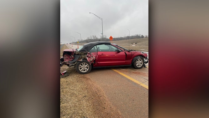
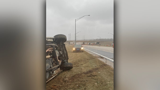
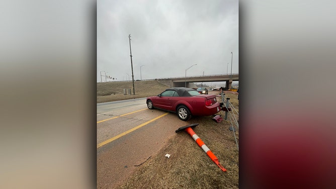
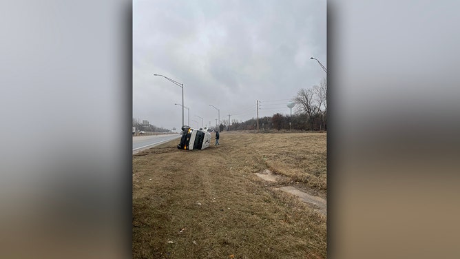
Farther south, the Oklahoma Highway Patrol reported dozens of crashes across the Oklahoma City metro area on Tuesday morning. Many semi-trucks have jackknifed. Troopers attributed the accidents to drivers speeding in hazardous weather conditions.
![Oklahoma Highway Patrol reports numerous crashes across the Oklahoma City metro area on Tuesday morning. Many semi-trucks have jackknifed. Troopers attribute the accidents to drivers speeding in hazardous weather conditions.]() Image 1 of 4
Image 1 of 4Oklahoma Highway Patrol reports numerous crashes across the Oklahoma City metro area on Tuesday morning. (OK Highway Patrol/DPS)
![Oklahoma Highway Patrol reports numerous crashes across the Oklahoma City metro area on Tuesday morning. Many semi-trucks have jackknifed. Troopers attribute the accidents to drivers speeding in hazardous weather conditions.]() Image 2 of 4
Image 2 of 4Oklahoma Highway Patrol reports numerous crashes across the Oklahoma City metro area on Tuesday morning. (OK Highway Patrol/DPS)
![Oklahoma Highway Patrol reports numerous crashes across the Oklahoma City metro area on Tuesday morning. Many semi-trucks have jackknifed. Troopers attribute the accidents to drivers speeding in hazardous weather conditions.]() Image 3 of 4
Image 3 of 4Oklahoma Highway Patrol reports numerous crashes across the Oklahoma City metro area on Tuesday morning. (OK Highway Patrol/DPS)
![Oklahoma Highway Patrol reports numerous crashes across the Oklahoma City metro area on Tuesday morning. Many semi-trucks have jackknifed. Troopers attribute the accidents to drivers speeding in hazardous weather conditions.]() Image 4 of 4
Image 4 of 4Oklahoma Highway Patrol reports numerous crashes across the Oklahoma City metro area on Tuesday morning. (OK Highway Patrol/DPS)
Another semi-truck that was hauling eggs crashed Tuesday afternoon on the Will Rogers Turnpike in Oklahoma, spilling cartons of eggs all over the highway. The Oklahoma Highway Patrol posted photos of the crash and said there were minor injuries.
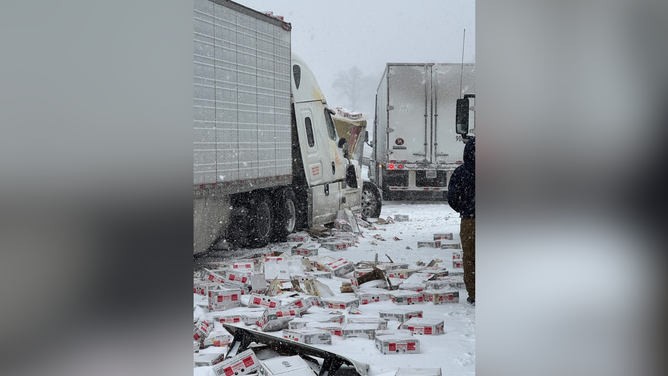
A semi-truck hauling eggs crashed on the Will Rogers Turnpike in northeast Oklahoma.
(@OHPDPS / X / FOX Weather)
The OHP said a semi-truck driver was caught on video cutting off and scraping an Oklahoma Turnpike snow plow on the Turner Turnpike near Sapulpa on Tuesday morning, and later crashed the same rig into the center barrier wall. The incidents are under investigation.

A semi driver was caught on video cutting off and scraping an Oklahoma Turnpike snow plow near Sapulpa, Oklahoma, on Tuesday.
(Oklahoma Highway Patrol)
For much of Tuesday, travel along Interstate 49 and Interstate 44 in Missouri and the Ozarks could be dangerous due to heavy snow and gusty winds, reducing visibility.
Missouri State Highway Patrol Troop D, which serves Southwest Missouri, reported 86 calls for service between midnight and 2 p.m. Central on Tuesday.
Twenty-six of those calls were for crashes, with five of those crashes leaving four people injured, authorities said.

Southwest Missouri could see their biggest snowstorm in 14 years
The Missouri Ozarks could see their biggest snowstorm in 14 years. Snow and wind are expected to intensify in Kansas City and Springfield, Missouri, creating dangerous, possibly impossible, driving conditions as early as Tuesday evening. Missouri Department of Transportation's Chief Safety and Operations Officer Becky Allmeroth joins FOX Weather with the latest.
On Tuesday afternoon, westbound I-44 near the Oklahoma state line was closed due to a multiple-vehicle crash.

Crash closes portion of I-44 near Missouri/Oklahoma state line
Winter weather is making travel dangerous in Missouri and Oklahoma, where a portion of westbound I-44 is closed because of a multiple vehicle crash.
The Missouri Department of Transportation warned drivers to stay off I-44 in Southern and Central Missouri because of travel conditions and multiple crashes.
FOX Weather Exclusive Storm Tracker Brandon Copic was in the Springfield area Tuesday evening, where he captured multiple crashes involving semi-trucks along I-44, which had the westbound lanes closed.
Foot of snow possible in some places
Major cities, including St. Louis and Springfield, Missouri, could see heavy snow. According to the FOX Forecast Center, Springfield was expected to see 5-8" before the precipitation shield moves eastward.

(FOX Weather)
The biggest winter weather impacts will happen across the Tennessee Valley on Wednesday.
Paducah, Kentucky, could see up to a foot of snow, and between 3 and 5 inches of snow is forecast in portions of Middle Tennessee.

(FOX Weather)
Some computer forecast models showed a major snowstorm potential along the Interstate 95 corridor in the mid-Atlantic and Northeast mid- to late-week, but those regions are now likely to miss out on any meaningful snow as the latest forecast shows the system staying farther south.
Accumulating snow appears most likely in the southern mid-Atlantic region, including parts of West Virginia, Virginia, North Carolina and the southern Delmarva Peninsula.
Winter Storm Watches and Warnings are in effect through Thursday for central and southern Virginia and central and eastern North Carolina. Snowfall accumulations could reach between 5 and 10 inches for these areas. Wind gusts around 35 mph will complicate travel, with hazardous conditions expected for the Wednesday evening commute.

(FOX Weather)
Be sure to check back with FOX Weather for updates as the forecast for this winter storm continues to evolve.