Winter Storm Watches posted in Chicago, Detroit as 2 more storms brew in parade of winter weather
The FOX Forecast Center said at least three separate winter storms are expected to sweep across a large portion of the U.S. during the week ahead, bringing the threat of widespread snow and ice to tens, if not hundreds, of millions of Americans from coast to coast.

Millions across US on alert as parade of winter storms sweep across nation
Tens of millions of people across the U.S. are on alert for a series of powerful winter storms that will be sweeping across the nation this week and into the weekend. FOX Weather Meteorologists Britta Merwin and Craig Herrera have the latest.
Fast Facts:
- Philadelphia, Baltimore and Washington are expecting plowable snow later Tuesday and into Wednesday morning.
- Damaging ice is expected in the central Appalachians, which could lead to power outages in Virginia.
- Treacherous travel is expected along the I-81 corridor.
- The next winter storm is brewing in the Plains and Midwest and has cities such as Chicago, Detroit and Kansas City on alert.
BOSTON – If you were hoping the U.S. had turned a corner and more springlike weather was on the way, you’re going to have to hold on a bit longer as the FOX Forecast Center continues to monitor an incredibly active week for winter weather across the nation.
This renewed threat comes just as millions of people across the Northeast and New England clean up in the wake of a winter storm over the weekend that dumped several inches of snow across the region.
Triple threat of winter storms looms this week

(FOX Weather)
The FOX Forecast Center said at least three separate winter storms are expected to sweep across a large portion of the U.S. during the week ahead, bringing the threat of widespread snow and ice to tens, if not hundreds, of millions of Americans from coast to coast.
Flooding, too, will be a concern, as torrential rain to the south falls across the Southeast as the parade of storms sweeps across the U.S.
Mid-Atlantic braces for heavy snow, ice that could snarl travel

(FOX Weather)
This latest winter storm is taking a more southerly track than the storm that impacted the Northeast and New England over the weekend, and that will bring the heaviest snow to Washington and Baltimore.
Rain and snow were already falling across portions of the region on Tuesday morning, where cities such as Louisville, Kentucky, and Cincinnati, Ohio, can expect a few inches of snow, along with the threat of a glaze of ice.
Farther south, it’s all rain.

(FOX Weather)
The heaviest snowfall and greatest impacts will occur in the Appalachians and parts of the mid-Atlantic as the storm gathers strength.
Higher elevations in West Virginia and Virginia, as well as parts of southern New Jersey, could see 3-5 inches of snow, with some areas potentially seeing 5-8 inches.
Cities such as Washington, Baltimore, Dover in Delaware and Atlantic City in New Jersey should expect to see snow.
To the south, significant freezing rain is expected across western and central Virginia, as well as in the mountains of western North Carolina.

(FOX Weather)
Winter Storm Watches and Warnings, as well as Winter Weather Advisories, stretch across the region.
Cities like Louisville, Kentucky; Charleston, West Virginia; Richmond and Roanoke, Virginia; Washington and Philadelphia are all included in the winter weather alerts.
TRAVELING THIS WINTER? HERE’S WHAT TO KEEP IN YOUR CAR IN CASE YOU GET STUCK
Forecasters tracking monster midweek storm that has Chicago, Detroit and Kansas City on alert

(FOX Weather)
A midweek winter storm is also being monitored by the FOX Forecast Center.
This one, forecasters said, will develop quickly on the heels of the system impacting the mid-Atlantic and Ohio Valley on Tuesday.
In fact, as that storm begins to wind down, this one will be gaining strength.
This system will bring snow to the Plains and Midwest beginning Wednesday, and this time, the forecast snow totals will be significant.
Heavy snow is possible from Kansas City, Missouri, to Chicago and Detroit by Wednesday night as the area of low pressure strengthens. Winter Storm Watches are posted for Chicago and Detroit, while Kansas City has been upgraded to a Winter Storm Warning.
In the Plains, a clash of air masses may also lead to ice in parts of Oklahoma and Missouri.

(FOX Weather)
As the system pushes off to the Northeast by Thursday, there is still some uncertainty regarding temperatures along the Interstate 95 corridor.
Trends have been warmer, meaning New York City and Philadelphia could once again miss out on a significant winter storm.
There is still time for the forecast to change, but computer forecast models show warmer temperatures in the mid-Atlantic, too, meaning this system could also be just plain rain.
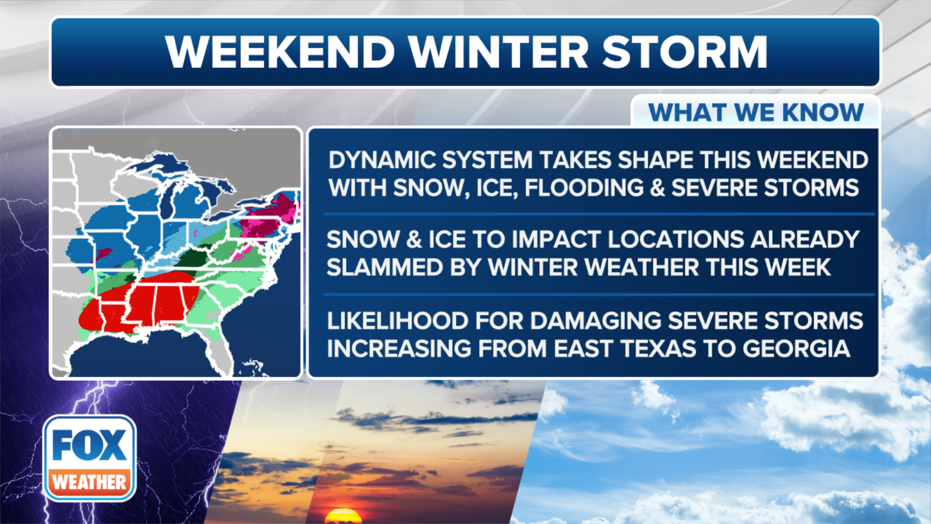
Weekend winter storm includes severe weather threat
(FOX Weather)
The winter storm threat won’t be letting up as we head into the weekend as the FOX Forecast Center tracks yet another system that will also have a severe weather component as it tracks across the U.S.
Unlike the previous storms that have been blasting the nation since last weekend, this low-pressure system associated with the weekend threat will rapidly strengthen over the Deep South rather than waiting until it nears the East Coast.
The jet stream has played a major role in how these storms have been moving across the Lower 48 and will take more of an amplified dip across the South rather than remaining flat.
Severe thunderstorms could develop ahead of the cold front, which will be the main driver of the system as it moves across the Southeast.
All severe weather threats, including hail, damaging wind gusts and tornadoes, will be possible.
![This graphic shows the forecast on Saturday, Feb. 15, 2025.]() Image 1 of 3
Image 1 of 3This graphic shows the forecast on Saturday, Feb. 15, 2025. (FOX Weather)
![This graphic shows the forecast on the evening of Saturday, Feb. 15, 2025.]() Image 2 of 3
Image 2 of 3This graphic shows the forecast on the evening of Saturday, Feb. 15, 2025. (FOX Weather)
![This graphic shows the forecast on Sunday, Feb. 16, 2025.]() Image 3 of 3
Image 3 of 3This graphic shows the forecast on Sunday, Feb. 16, 2025. (FOX Weather)


The FOX Forecast Center said the storm will generate widespread rain on its eastern side as it tracks off toward the Northeast.
That will limit, but not eliminate, the snow threat. Most snow, however, won’t develop until the system taps into the frigid air over the Midwest and New England.
Moderate to heavy snow is expected along the Interstate 90 corridor from Des Moines, Iowa, to Chicago and into New England.
That could potentially lead to another significant snowfall event, possibly up to a foot, north of Boston in northern New England and in parts of upstate New York.

(FOX Weather)
For cities along the Interstate 95 corridor, including New York City, Philadelphia and Washington, the same cold front fueling severe weather in the South could hold it together as it moves to the north.
In fact, some computer forecast models show there could even be some moderate warming that could lead to scattered thunderstorms.
This system is still several days out, so be sure to download the free FOX Weather app and enable notifications to be alerted to any changes in the forecast.