How Ida's small eye compares to other major hurricanes that have struck the US
A smaller eye typically means a hurricane has higher wind speeds
FOX Weather multimedia journalist blown by wind during Hurricane Ida
FOX Weather Multimedia Journalist Robert Ray showed just how powerful Hurricane Ida was by getting blown down the sidewalk twice.
Hurricane Ida made landfall in southeastern Louisiana on Sunday as a high-end Category 4 hurricane with maximum sustained winds of 150 mph.
The storm crossed the Gulf Coast near Port Fourchon, Louisiana, at 11:55 a.m. Central time Sunday, the National Hurricane Center said.
Ida tied Hurricane Laura (2020) and the Last Island hurricane (1856) for Louisiana's strongest landfall on record in terms of maximum wind speeds, according to Dr. Phil Klotzbach, a tropical scientist at Colorado State University. NHC records date back to 1851.
1 DEAD, MORE THAN 1 MILLION WITHOUT POWER AS IDA BATTERS GULF COAST
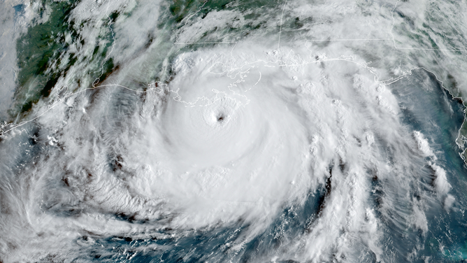
Satellite imagery captured Hurricane Ida at peak intensity Sunday morning, and one thing that stood out to meteorologists was the size of its eye: It was very small.

Visible satellite imagery captured Category 4 Hurricane Ida at peak intensity as it approached the coast of southeastern Louisiana Sunday, Aug. 29, 2021.
(Colorado State Univ./CIRA/RAMMB)
The eye is the calmest part of a hurricane located at its center, often featuring clear skies and light winds. The entire hurricane rotates counterclockwise around the eye.
In general, the smaller a hurricane's eye, the faster it spins. Put another way, a smaller eye typically means a hurricane has higher wind speeds.
#HurricaneIda is weakening, which is good news, but it still did a lot of damage. Looking down the eye from above gives perspective of how high these clouds are… Thinking of all those affected. Stay safe! #MissionAlpha pic.twitter.com/Y8PGi4Rjqd
— Thomas Pesquet (@Thom_astro) August 30, 2021
"It's all a matter of physics. Just like a figure skater can spin faster when they pull their arms and legs in tight, the same thing happens at the center of a tropical cyclone," said FOX Weather meteorologist Shane Brown. "In order to conserve a property known as angular momentum, as the eye contracts and inertia decreases, there has to be an opposite effect outward. We notice this as the wind speed increasing."
The NHC said in its discussion at 10 a.m. Central time Sunday that Hurricane Ida had a 17-mile-wide eye. Estimates from Doppler radar and Hurricane Hunter reconnaissance aircraft indicated the eye was about 18 miles wide.
You can see the bands wrapped around the eye and eye wall from #Ida really well on radar. These bands will have the strongest winds in the system. Stay safe y’all! #mswx #lawx pic.twitter.com/8kJRwLLkKQ
— NWS New Orleans (@NWSNewOrleans) August 29, 2021
According to Brown, an average hurricane's eye is about 30 miles wide, so Ida's was certainly on the smaller side. However, it was nowhere near as small as the eyes of some other major hurricanes that have struck the United States in the past, data from the NHC shows.
- Hurricane Wilma (2005): eye diameter of 2 miles, 175-mph winds. Wilma holds the record for the smallest-known hurricane eye in the Atlantic Basin.
- Hurricane Charley (2004): eye diameter of 3 miles, 150-mph winds.
- Hurricane Delta (2020): eye diameter of 5 miles, 140-mph winds.
- Hurricane Dennis (2005): eye diameter of 5 miles, 120-mph winds.
- Hurricane Opal (1995): eye diameter of 6 miles, 150-mph winds.
- Hurricane Andrew (1992): eye diameter of 7 miles, 165-mph winds
- Hurricane Maria (2017): eye diameter of 10 miles, 175-mph winds.
Not including Ida, the other seven hurricanes listed above all had what's known as a "pinhole eye."
Pinhole eyes are those that are less than 10 miles in diameter. Nearly 60% of hurricanes with eyes this small reach major-hurricane status – Category 3 or higher on the Saffir-Simpson Hurricane Wind Scale – according to a study published in 2012 by Colorado State University and the National Center for Atmospheric Research.
HOW ARE HURRICANES RATED? THE SAFFIR-SIMPSON HURRICANE WIND SCALE EXPLAINED
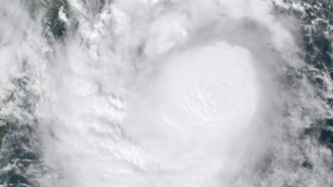
Oftentimes, pinhole eyes aren't even visible on satellite imagery because they are so small. That was the case with Hurricane Delta in 2020.

Hurricane Delta's 5-mile-wide eye was too small to be seen on visible satellite imagery on Oct. 6, 2020.
(Colorado State Univ./CIRA/RAMMB)
