Tidal flooding continues as rain shifts to the Northeast
Strong onshore winds associated with a large storm system piled water into tidal regions.
After seeing some of the worst coastal flooding since Hurricane Isabel in 2003 in the Mid-Atlantic Friday, the same storm system will shift to the Northeast for the weekend.
The combination of heavy rains and strong winds contributed to tidal flooding, especially during periods of high tides, from Virginia to New Jersey on Friday.
Tidal levels will slowly decrease on Saturday for the Mid-Atlantic as the storm heads towards New England.
Heavy rains and a continued onshore flow could help trigger flooding in poor drainage areas from Rhode Island to Maine on Saturday.
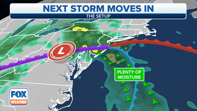
East storm setup for October 30, 2021.
The area with the highest flood threat from rainfall over the weekend stretches from eastern New Hampshire through coastal Maine.
Coastal Flood Warnings are in effect until 1 a.m. EDT Sunday.
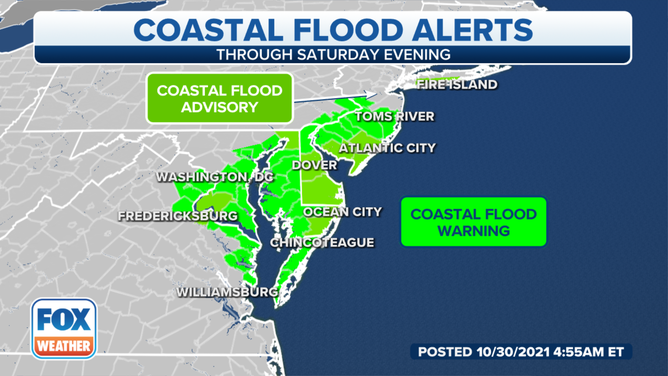
Coast Flood Alerts for October 30, 2021.
(FOX Weather)
The National Weather Service says flooding may become severe enough to cause structural damage and widespread roadway flooding near tidal waterways.
Forecast models indicate widespread rains of two to four inches, beginning Saturday and lasting through Halloween.
Historic Tides
![]() Image 1 of 13
Image 1 of 13WASHINGTON, DC - OCTOBER 29: Rising water covers a walkway along the Tidal Basin after heavy rains caused tidal flooding in the Mid-Atlantic region on October 29, 2021, in Washington, DC. A storm system with gusty winds and heavy rain is bringing significant coastal and tidal flooding to Washington DC, Virginia and Maryland. (Drew Angerer/Getty Images)
![]() Image 2 of 13
Image 2 of 13WASHINGTON, DC - OCTOBER 29: Rising water covers upstairs along the Tidal Basin after heavy rains caused tidal flooding in the Mid-Atlantic region on October 29, 2021 in Washington, DC. A storm system with gusty winds and heavy rain is bringing significant coastal and tidal flooding to Washington DC, Virginia and Maryland. (Drew Angerer/Getty Images)
![]() Image 3 of 13
Image 3 of 13WASHINGTON, DC - OCTOBER 29: A tree is partially submerged in the Potomac River after heavy rains caused tidal flooding in the Mid-Atlantic region on October 29, 2021 in Washington, DC. A storm system with gusty winds and heavy rain is bringing significant coastal and tidal flooding to Washington DC, Virginia and Maryland. ( )
![]() Image 4 of 13
Image 4 of 13A group of people take photos with their phones as flood waters rise in downtown Annapolis, Maryland, on October 29, 2021. - The US National Weather Service implemented a flood watch for the cities of Baltimore and Annapolis as well as Anne Arundel, Baltimore and Howard counties. Washington, DC, and parts of Virginia faced the same alert. (JIM WATSON/AFP via Getty Images)
![]() Image 5 of 13
Image 5 of 13A hold for kayaks is seen flooded in high water in Old Town Alexandria, Virginia, on October 29, 2021. - The US National Weather Service has implemented a flood watch for Maryland, Washington, DC, and parts of Virginia. Flooding from heavy rain hit parts of the US East Coast on October 29, particularly the area around Washington, with potential for some of the worst damage in decades. (ANDREW CABALLERO-REYNOLDS / AFP) (Photo by ANDREW CABALLERO-REYNOLDS/AFP via Getty Images)
![]() Image 6 of 13
Image 6 of 13The bar manager at the Union Street pub hands a drink to Keith Harmon (L) and Heidi DeuPree as they paddle through flood water in a canoe in Old Town Alexandria, Virginia, on October 29, 2021. - The US National Weather Service has implemented a flood watch for Maryland, Washington, DC, and parts of Virginia. Flooding from heavy rain hit parts of the US East Coast on October 29, particularly the area around Washington, with potential for some of the worst damage in decades. (ANDREW CABALLERO-REYNOLDS / AFP) (Photo by ANDREW CABALLERO-REYNOLDS/AFP via Getty Images)
![]() Image 7 of 13
Image 7 of 13A group of people wade through flood waters in downtown Annapolis, Maryland, on October 29, 2021. - The US National Weather Service implemented a flood watch for the cities of Baltimore and Annapolis as well as Anne Arundel, Baltimore and Howard counties. Washington, DC, and parts of Virginia faced the same alert. (JIM WATSON/AFP via Getty Images)
![]() Image 8 of 13
Image 8 of 13Keith Harmon and Heidi DeuPree paddle through flood water in a canoe in Old Town Alexandria, Virginia, on October 29, 2021. - The US National Weather Service has implemented a flood watch for Maryland, Washington, DC, and parts of Virginia. Flooding from heavy rain hit parts of the US East Coast on October 29, particularly the area around Washington, with potential for some of the worst damage in decades. (NDREW CABALLERO-REYNOLDS/AFP via Getty Images)
![]() Image 9 of 13
Image 9 of 13A police officer pulls a potted plant across a flooded street near a bar in Old Town Alexandria, Virginia, on October 29, 2021. - The US National Weather Service has implemented a flood watch for Maryland, Washington, DC, and parts of Virginia. Flooding from heavy rain hit parts of the US East Coast on October 29, particularly the area around Washington, with potential for some of the worst damage in decades. (ANDREW CABALLERO-REYNOLDS / AFP) (Photo by ANDREW CABALLERO-REYNOLDS/AFP via Getty Images)
![]() Image 10 of 13
Image 10 of 13Sand bags are seen in front of a store to keep out flood water in Old Town Alexandria, Virginia, on October 29, 2021. - The US National Weather Service has implemented a flood watch for Maryland, Washington, DC, and parts of Virginia. Flooding from heavy rain hit parts of the US East Coast on October 29, particularly the area around Washington, with potential for some of the worst damage in decades. (ANDREW CABALLERO-REYNOLDS / AFP) (Photo by ANDREW CABALLERO-REYNOLDS/AFP via Getty Images)
![]() Image 11 of 13
Image 11 of 13People watch a man walk through a flooded street in Old Town Alexandria, Virginia, on October 29, 2021. - The US National Weather Service has implemented a flood watch for Maryland, Washington, DC, and parts of Virginia. Flooding from heavy rain hit parts of the US East Coast on October 29, particularly the area around Washington, with potential for some of the worst damage in decades. (ANDREW CABALLERO-REYNOLDS / AFP) (Photo by ANDREW CABALLERO-REYNOLDS/AFP via Getty Images)
![]() Image 12 of 13
Image 12 of 13A woman reacts as she walks through a flooded street in Old Town Alexandria, Virginia, on October 29, 2021. - The US National Weather Service has implemented a flood watch for Maryland, Washington, DC, and parts of Virginia. Flooding from heavy rain hit parts of the US East Coast on October 29, particularly the area around Washington, with potential for some of the worst damage in decades. (ANDREW CABALLERO-REYNOLDS / AFP) (Photo by ANDREW CABALLERO-REYNOLDS/AFP via Getty Images)
![]() Image 13 of 13
Image 13 of 13A woman reacts as she walks through a flooded street in Old Town Alexandria, Virginia, on October 29, 2021. - The US National Weather Service has implemented a flood watch for Maryland, Washington, DC, and parts of Virginia. Flooding from heavy rain hit parts of the US East Coast on October 29, particularly the area around Washington, with potential for some of the worst damage in decades. (ANDREW CABALLERO-REYNOLDS/AFP via Getty Images)


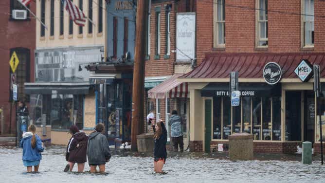


On Friday, significant street flooding in Old Town Alexandria, Virginia forced many streets to close and businesses employed the use of sandbags to keep rising waters at bay.
Similar flooding was reported in Washington, DC, including areas around the National Mall.
WTOP News’ Valerie Bonk captured video of workers at The Wharf using boats to get back and forth to restaurants surrounded by floodwaters.
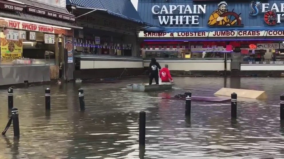
Tidal flooding impacts D.C.
WTOP News' Valerie Bonk captured flooding at The Wharf in D.C.
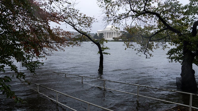
Historical sites around the Tidal Basin weren’t immune from the flooding.
Some memorials resembled islands, as waters rose to their highest levels since Hurricane Isabel back in 2003.
The official gauge near the U.S. Army’s Fort Lesley J. McNair site reached 7.12 feet, making Friday’s event the area’s 15th highest crest in reported history.
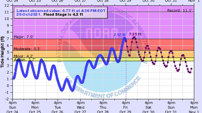
A tidal gauge near the National Mall reached major flood status on Friday.
(NOAA)
And in Maryland, Governor Larry Hogan declared a state of emergency for low-lying areas after floodwaters damaged dozens of homes and left streets impassable from the Delmarva Peninsula to Baltimore.
"Even if you are accustomed to nuisance flooding, this is much more serious and has the potential to be much more damaging over the course of the next 24 hours," said Governor Hogan. "We are taking this action to bring all necessary state resources to bear, and assist local jurisdictions in their response efforts. We urge Marylanders to remain vigilant, to stay tuned to local news stations for the latest updates, and to follow any instructions local officials may provide."
The increased tides even caused flooding late Friday night in areas along the Delaware River.
Motorists were caught off-guard in Philadelphia, as waters rose to levels not seen since Hurricane Sandy in 2012.
Despite widespread coastal flooding, authorities have not reported any injures or deaths associated with the weather.