Tracking Ian through the mid-Atlantic; impacts from wind and rain expected along I-95 corridor
Hurricane Ian made its final landfall in South Carolina on Friday after producing catastrophic damage earlier this week in Florida. Ian is now impacting the mid-Atlantic with gusty winds and heavy rainfall.
Coverage for this event has ended.
Live coverage of Ian for Saturday, 10/1, has ended here. For continuing coverage visit: Foxweather.com
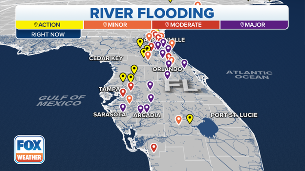
Despite the rain ending days ago, some lakes and rivers in Central and South Florida continue to rise. Rescues and evacuations continue in some communities:
A couple came face-to-face with the fury of Hurricane Ian when water burst through the door of their condominium building in Naples.
Ian made landfall Wednesday afternoon as a monstrous Category 4 hurricane with 150 mph winds and a tremendous storm surge.
That surge was captured on video and the residents lived to tell the story:
The Florida Division of Emergency Management reports more than 1,000 people have been rescued and evacuated from flooded areas in Central and Southwest Florida.
The official number of rescued is likely much higher due to private groups and volunteers that are assisting with efforts.
Floodwaters continue to rise in some communities as runoff makes its way into streams and lakes.
Florida Governor Ron DeSantis said his team is working with Elon Musk to get internet service to the disaster zone.
Musk’s Starlink service has done similar has done similar tasks for areas impacted by war and natural disasters.
Crews continue to work on restoration of utilities across the state. At last report, more than 1 million Floridians remain without power across the state.A
Related link: After 'space laser' upgrade SpaceX continues launching Starlink internet constellation
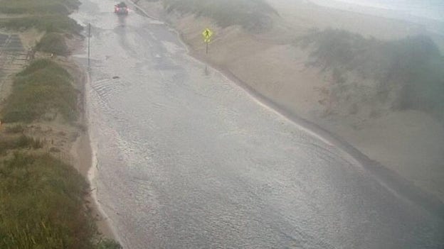
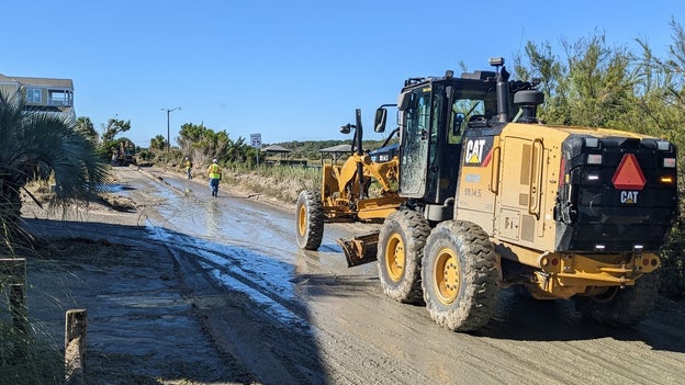
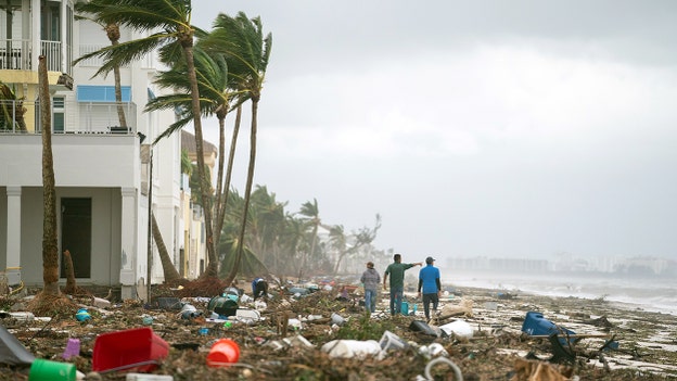
Travel continues to be slow along North Carolina Highway 12 as the Outer Banks continue to deal with sand and water from the impacts of Hurricane Ian.
The state’s department of transportation is monitoring the thoroughfare and cautions travelers that driving conditions maybe poor.
Crews are working to clear the roadway of debris and overwash. Water levels are expected to remain high through the weekend due to the onshore flow.
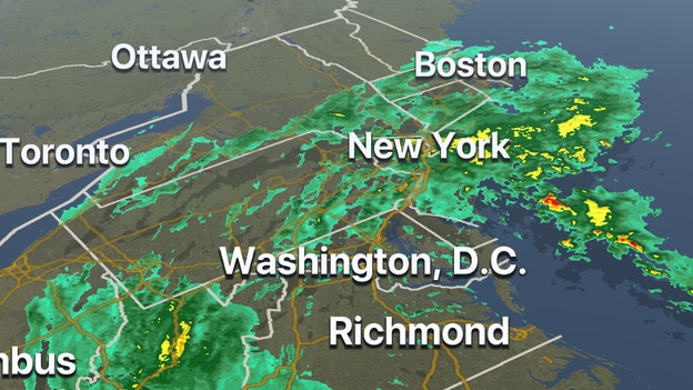
NOAA’s Weather Prediction Center continues to track the remnants of Ian over the Appalachians as the system impacts many states.
As of 5 p.m., the center was located about 95 miles west of Richmond, Virginia but impacts stretch outwards from the center hundreds of miles in the form of heavy rain and gusty winds.
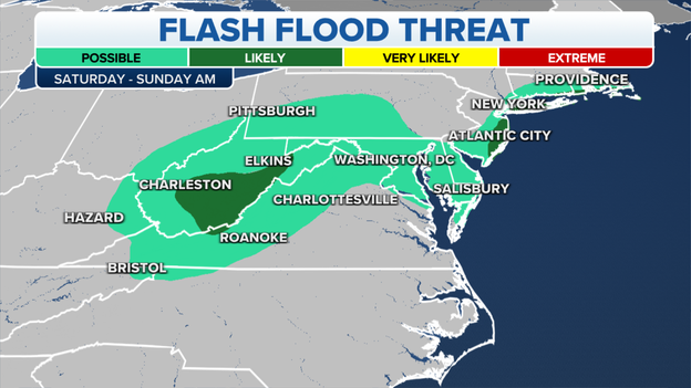
The FOX Forecast Center said Ian could produce 1 to 3 inches of rain from West Virginia, to Virginia and Maryland through Sunday.
The WPC warns the rainfall could lead to urban and small stream flooding across western Maryland and West Virginia.
Tracking Ian: Where the remnants will head next
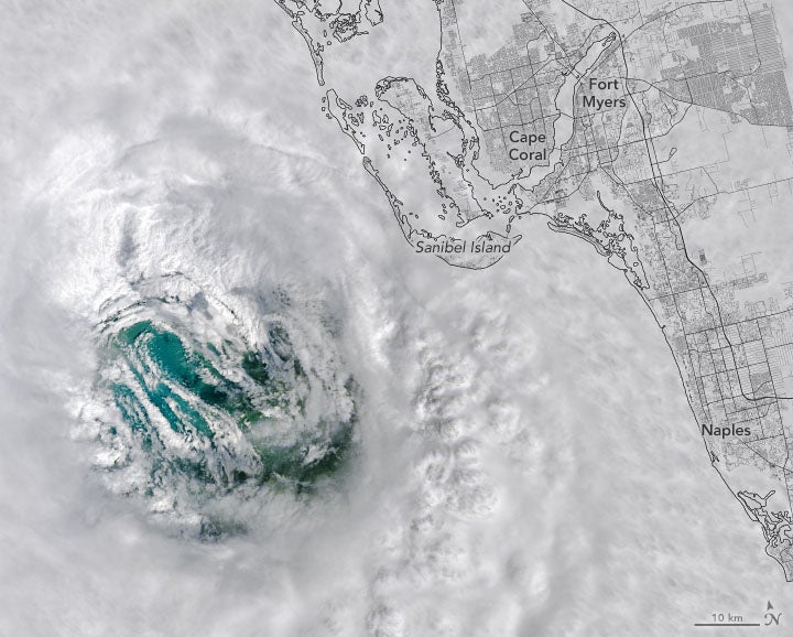
A NOAA satellite captured the combination of freshwater and sentiment making its way from the Everglades and Southwest Florida into the Gulf of Mexico.
The National Weather Service said whenever a powerful hurricane makes its way through the region, the scene is usually repeated because underwater currents can suspend the mixture at the surface, making it visible to satellites.
The process is naturally driven and is not an indication of widespread contamination or pollution.
Florida’s Department of Transportation reports crews are in the process of reopening I-75 after flooding forced the interstate to close overnight, north of Port Charlotte.
FDOT warns the interstate may be forced to close again due to varying water levels in nearby waterways.
The highway is the main route for evacuees returning home south of Venice, Florida.
The region saw nearly 20 inches of rain during a period of only a couple of days.
Updated traffic info can be found at: www.FL511.com
SpaceX announced they are targeting Wednesday, October 5 for a launch of a crewed mission to the International Space Station from Launch Complex 39A at NASA's Kennedy Space Center in Florida.
The Kennedy Space Center was impacted by tropical storm-force winds and heavy rain when Ian passed through Central Florida.
NASA said damage to facilities was minor and would not impact space operations.
South Carolina Department of Transportation crews are busy clearing sand and debris from coastal communities including Pawleys Island.
Pawleys Island was hard hit by several feet of storm surge when Hurricane Ian made landfall as a Category 1 storm on Friday.
Crews caution anyone driving in the hard hit areas to be careful and use caution.
The death toll continues to rise from Hurricane Ian and now is at more than two dozen. North Carolina reported at least four deaths associated with the storm. According to the state:
-A 25-year-old man died Friday when he lost control of his vehicle on Raleigh Road in Johnston County and hydroplaned into another vehicle in stormy conditions
-A 24-year-old woman died when her vehicle went off a wet road in Clayton and struck a tree Friday afternoon
-A 22-year-old man drowned in Martin County when his truck left the roadway and submerged in a flooded swamp Friday night
-A 65-year-old man in Johnston County died Saturday from carbon monoxide poisoning from a generator running in his closed garage while the power was out. His wife was hospitalized.
Read more about rescue and recovery efforts:
Despite sunny, dry conditions the extreme rainfall from Hurricane Ian is slowly working its way into waterways in the south and central parts of the Peninsula. This is leading to major flooding and even forced the closure of I-75 south of Venice, Florida. River outlooks indicate it could be several days before water levels recede to more manageable levels.
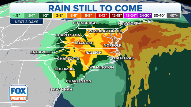
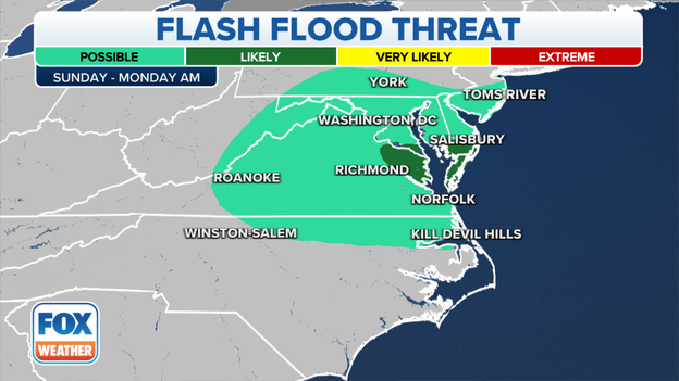
Ian's remnants aren't done yet. The system will continue to impact areas from North Carolina through New Jersey through at least Monday.
By early workweek some areas could see upwards of 5 inches of rain on already saturated grounds, which could make some trees unstable.
Updated forecast: Who will see the rain and wind
It's estimated only 13-15% of Florida homeowners have flood insurance and in inland communities that number can drop below 5%. Impacts on homeowners:
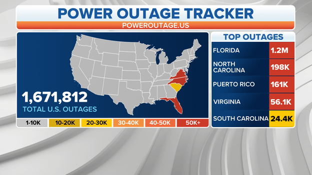
Utility companies are working in states across the Southeast to restore power as quickly as possible from Ian. At last count, around 1.5 million customers from Florida to Virginia were without power. The combination of wind and rain can cause trees with weak root systems to fall over, bringing down additional power lines. That is a concern for states with a heavy tree canopy.
Florida: 1,200,000+ (Decreasing trend)
South Carolina: 24,000 + (Decreasing trend)
North Carolina: 198,000+ (Decreasing trend)
Virginia: 56,000+ (Growing trend)
7 Ways to stay safe while using a generator: Learn more
FOX Weather correspondent Max Gorden found a distribution site Saturday in hard-hit Fort Myers, Florida, that had been set up by the Cajun Navy, and said hundreds of cars were waiting in line to get supplies. He reported that the need is so great that it appeared supplies were running low.
Gorden also said that more and more residents are returning to find their homes in shambles.
Search and rescue missions continue Saturday in some of Florida's hardest hit areas of Sanibel, Captiva, and Pine Island following Hurricane Ian.
The 96-member crew of the Miami-Dade Fire Rescue Florida Task Force One Team is assessing damages and looking for survivors in the areas devastated by the storm.
In Sanibel Island, teams are by walking the roads and stopping door-to-door to check on those trapped inside their homes and who need assistance.
"Our task force, along with other search and rescue squads, have been loading up survivors and pets and transporting them to the Sanibel Fire Station, where helicopters are on standby to assist in the evacuation operations," the agency said in a written statement.
Due to the treacherous terrain and inaccessible roads, crews have been working alongside the Florida National Guard and the United States Coast Guard to rescue residents from their severely damaged homes and fly them back into a safe zone on the mainland where they can receive medical attention.
Drones do the hard work, learning the secrets that hurricanes hide within their two-story waves and 130-mph winds.
On Wednesday, the National Oceanographic and Atmospheric Administration researchers flew a drone into Hurricane Ian to collect weather measurements in a part of the storm too dangerous for Hurricane Hunters.
Called an Area-I Altius-600 uncrewed aircraft system (UAS), the drone was the first of its kind to be deployed into a hurricane by NOAA. The 27-pound UAS was released into Hurricane Ian from a NOAA WP-3D Hurricane Hunter aircraft (N42RF, "Kermit") on Sept. 28.
Lee County Sheriff Carmine Marceno said there have been "about 35" confirmed deaths in the wake of now-Post-Tropical Cyclone Ian.
He provided an update Saturday from outside the Emergency Operations Center.
"Today, we've had over 600 to 700 rescues of people that are in need during this difficult time," he said.
Marceno said utility crews are working around the clock to restore power to residents do they get back to some normalcy.
"There's light at the end of the tunnel," he said. "We are going to work harder, and we are going to be stronger than ever. And I ask of you to be part of this team. We are one big family together. That's what makes us great. And sometimes, these horrific events bring us all together for us to move forward."
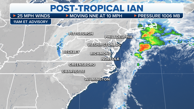
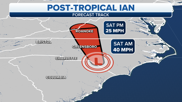
The center of Post-Tropical Cyclone Ian was moving toward the north-northeast near 10 mph, and the motion is expected to continue today with a gradual turn to the southeast tonight, the National Hurricane Center said.
Maximum sustained winds are near 25 mph with higher gusts. The estimated minimum central pressure is 1006 millibars.
A gradual weakening trend is forecast through Sunday.
Ian is expected to produce an additional 1 to 3 inches of rainfall, with locally heavier amounts possible, across portions of the central Appalachians and mid-Atlantic.
Major to record river flooding will continue across central Florida through next week.
The circulation that was Hurricane Ian will die this weekend over North Carolina or Virginia. The few leftover pockets of gusty winds will slowly wind down. The threat now switches to the effects of the rain that fell over the higher terrain in the Southeast and the record rainfall left behind in Florida.
FOX Weather hurricane specialist Bryan Norcross has more in his latest post below.
President Joe Biden declared that an emergency exists in North Carolina and ordered federal assistance to supplement response resulting from Hurricane Ian.
His action authorizes FEMA to coordinate all disaster relief efforts.
FEMA Administrator Deanne Criswell has named John F. Boyle as the federal coordinating officer for federal recovery operations in the affected areas.
FEMA also announced Saturday that federal disaster assistance has been made available to the Seminole Tribe of Florida to supplement tribal recovery efforts in the areas affected by Ian.
Watch as Florida Power & Light CEO and Chairman Eric Silagy gives an update on power restoration following Hurricane Ian.
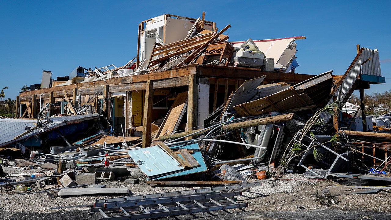
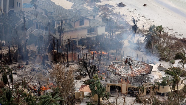
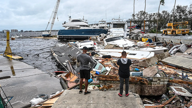
Ian caused historic damage to southwest Florida, decimating homes and roadways and leaving countless people with nothing.
In his own words, Lee County Sheriff Carmine Marceno explains how emergency teams are responding and helping those in need.
A weakened levee could potentially flood a community in Sarasota County, the sheriff’s office said, though it clarified that the flooding danger is limited to one neighborhood despite a phone alert apparently being sent countywide.
Several residents in the county posted on social media that they received an automated message on their phones early Saturday morning warning of a possible levee break along the Myakka River.
The National Weather Service in Tampa, fielding several tweets from worried residents, sent multiple replies stating there is "no expected change in impacts" to the Myakka River, though "flooding does continue".
But the Sarasota County Sheriff’s Office says they indeed sent an alert just before 3 a.m. indicating a possible levee break in the Hidden River community. But those signed up for the alerts anywhere in the county likely received the notification.
They clarified on Twitter that the danger is only for homes on the east side of the Hidden River community and no other areas of Sarasota are affected.
“At this time, deputies are working with Sarasota County Fire personnel to go door-to-door and advise residents of potential flooding,” the Sarasota County Sheriff wrote. “Residents are encouraged to consider evacuation.”
The FOX Forecast Center said Ian dropped 19 inches of rain in North Port in just over two days. The river has reached more than 2 feet over major flood stage and just topped its record crest by about an inch. A 14-mile stretch of I-75 is closed near North Port and Englewood due to the river flooding.
FOX Weather Meteorologist Kelly Costa breaks down the current situation in the tropics.
The Jacksonville Port Authority is open, and operations have resumed Saturday morning.
"Thank you to the @USCG, @CBP, & our JAXPORT employees & partners for their hard work to safely reopen the port after #Ian, ensuring we can continue to provide supply chain security for Florida, Puerto Rico & all communities we serve," the agency said in a tweet.
Ian left devastating damage and over a million without power across Florida and the Carolinas.
Here's a live look at Florida and the Carolinas.
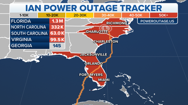
Here's a look at the latest outages across the Southeast:
FLORIDA: 1,303,267
NORTH CAROLINA: 330,858
SOUTH CAROLINA: 63,020
VIRGINIA: 99,595
The remnants of Ian are continuing to swirl just north of Greensboro, N.C. early Saturday morning.
The storm now just has maximum winds of 35 mph and is moving north at 12 mph, according to the National Hurricane Center. Its central pressure is now up to 1001 millibars.
The former Ian is expected to move north across central North Carolina and into south-central Virginia by Saturday afternoon. The wind threat has largely vanished but Ian is still bringing heavy rains to the mid-Atlantic states with 2-4 inches expected across the region, though isolated areas of 6-inch rainfall totals are possible in the Central Appalachians and coastal Mid-Atlantic.
Meanwhile, central Florida is still dealing with swollen rivers from Ian's pass through the Sunshine State on Wednesday and Thursday. Major to record flooding is expected through next week.
The National Hurricane Center says their 5 a.m. Saturday update is their final one on what was Hurricane Ian. Further forecasts and advisories will be left to NOAA's Weather Prediction Center, which is in charge of heavy rain events.
Rescue and recovery efforts are underway in Florida after one of the strongest hurricanes to ever hit the U.S. decimated several towns on the state's southwest coast.
Hurricane Ian made landfall Wednesday afternoon near Cayo Costa, Florida, as a catastrophic Category 4 storm with 150 mph winds. Those winds pushed water from the Gulf of Mexico ashore, flooding homes and washing away roads needed to access the beachfront locales.
Ian exited Florida on Thursday before making a run at the South Carolina coast, where it made landfall Friday as a Category 1 hurricane with 85 mph winds.
Read more here about what the Florida District of Medical Examiners confirmed.
Operations at Florida's spaceport are getting back to normal after Hurricane Ian's rampage throughout the state.
NASA and SpaceX are now targeting Wednesday, Oct. 5, to launch an American, Japanese and Russian astronaut crew to the International Space Station.
Read more about the launch here.
Residents in Naples, Florida are figuring out the next steps for clean-up and recovery.
As of the overnight update, the remnants of Hurricane Ian were located about 60 miles south of Greensboro, North Carolina.
Wind gusts of around 50 mph were still being reported, which is strong enough to cause some tree damage and power outages.
All Tropical Storm and Storm Surge Watches and Warnings have been discontinued but coastal surf conditions will remain rough the weekend.
Ian is forecast to weaken through Saturday and dissipate by Sunday.
Ian’s impacts through the weekend: Forecast details
Residents from North Carolina to Virginia and the Appalachians will see gusty winds and heavy rainfall on Saturday as the remnants of Ian rain themselves out.
Virginia and West Virginia could be the benefactors of much of the heavy rain, which could lead to flooding and scattered power outages.
Forecast: Tracking remnants of Ian
Heavy delays were reported along Interstate 75 between Venice and Port Charlotte as evacuees encountered flooding along one of the main reentry routes.
Officials closed part of the major interstate Friday evening.
The FOX Forecast Center said Ian dropped 19 inches of rain in North Port in just over two days.
Live coverage of Hurricane Ian from Friday, 09/29, is available by clicking here.
Live Coverage begins here
