First nor'easter of season to lash Northeast coast with high winds, heavy rain and flooding
Widespread power outages are expected, the National Weather Service said
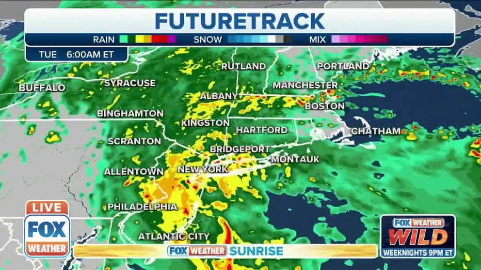
Tracking the season's first nor'easter
First nor’easter of season to lash Northeast coast with high winds, heavy rain and flooding
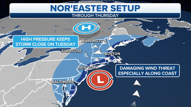
A rapidly strengthening storm system will become a nor'easter off the Northeast coast, lashing areas from New Jersey to New England with high winds, heavy rain and flooding.
High pressure in southeastern Canada will interact with this strong low-pressure system off the Northeast coast, creating a damaging wind threat along the coast due to the enhanced pressure difference between the high and the low.
(FOX Weather)
Several water rescues were reported Tuesday morning in Monmouth County, New Jersey, where 1.5 to 3.5 inches of rain had fallen overnight, according to the National Weather Service.
LIVE UPDATES: TRACKING FIRST NOR'EASTER OF THE SEASON
Street flooding was also reported early Tuesday in parts of central and northern New Jersey, prompting some road closures in the area. The NWS received several reports of flooding Tuesday morning along Interstate 287 near Edison, New Jersey, where emergency crews were dispatched to vehicle accidents on the highway.
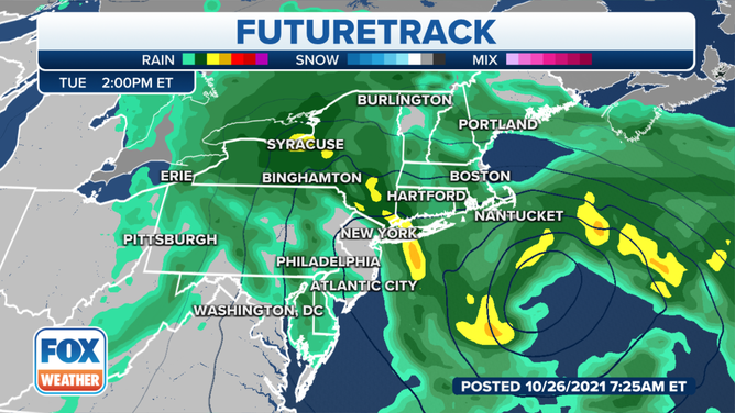
Forecast rain and pressure Tuesday afternoon, Oct. 26, 2021.
(FOX Weather)
The nor'easter will intensify off the coast of New Jersey on Tuesday, spreading bands of heavy rain across much of the Northeast through the day and into Wednesday.
WHAT MAKES A STORM A NOR'EASTER?
Many areas from New Jersey to Maine will receive 2 to 5 inches of rain, with locally higher amounts of 5 to 8 inches possible in some spots.
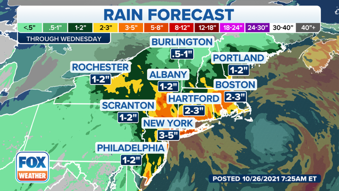
Rainfall forecast through Wednesday, Oct. 27, 2021.
(FOX Weather)
The NWS has issued Flash Flood Watches from central New Jersey and northeastern Pennsylvania into southeastern New York and much of Massachusetts, where the heaviest rain is expected from this nor'easter.
Rainfall rates may exceed 1 inch per hour at times, which could cause roadway flooding and ponding of water in low-lying areas.
The Tuesday evening commute will likely be impacted by high winds and heavy rain.
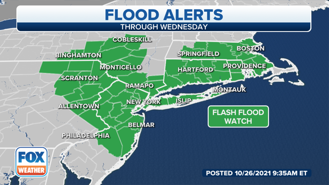
Flood alerts, shaded in green, are issued by the National Weather Service.
(FOX Weather)
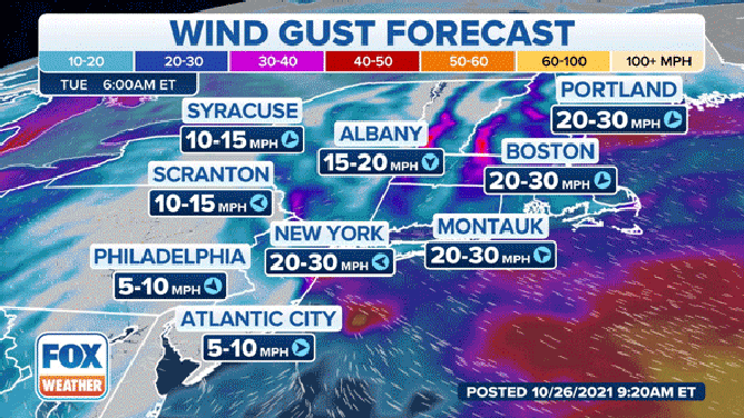
Wind gusts as high as 50 to 60 mph are possible from Long Island to eastern Massachusetts and coastal Maine. These winds will be capable of knocking down trees and power lines.
Widespread power outages are expected, the NWS said. Travel will be difficult, especially for high-profile vehicles.
NOR'EASTER IMPACTS: DANGEROUS WINDS TO PICK UP OVERNIGHT
A timeline of the nor'easter wind impacts for the Northeast.
(FOX Weather)
The winds are predicted to reach their peak intensity late Tuesday into early Wednesday, with the strongest gusts expected along the coast, though winds will still reach 30 to 50 mph farther inland.
WHY THE SCIENCE OF SUPERSTORM SANDY WAS BOTH NORMAL AND ABNORMAL
The NWS has issued High Wind Warnings and Wind Advisories through early Wednesday afternoon for portions of eastern and southeastern Massachusetts, including Martha's Vineyard and Nantucket, Rhode Island, eastern and southeastern Connecticut, central and eastern Long Island, coastal New Hampshire and coastal Maine.
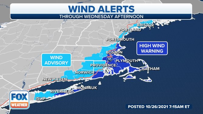
Wind alerts, shaded in blue, are issued by the National Weather Service.
(FOX Weather)
New Jersey Governor Phil Murphy issued a state of emergency Monday for all 21 counties in the state. Murphy said his order allows resources to deal with the storm to be deployed across the state.
New York City Emergency Management also issued a travel advisory for the city through Tuesday afternoon, warning drivers of impacts to both their morning and evening commutes on Tuesday.
It's not out of the question this nor'easter could acquire some tropical or subtropical characteristics later in the week while it moves eastward away from the Northeast coast.
HERE'S WHY THE ATLANTIC HURRICANE SEASON RUNS FROM JUNE TO NOVEMBER
The National Hurricane Center has given it a 50% chance of development in the next five days. If it becomes a named storm, it would earn the final name on this year's naming list for the Atlantic: Wanda.
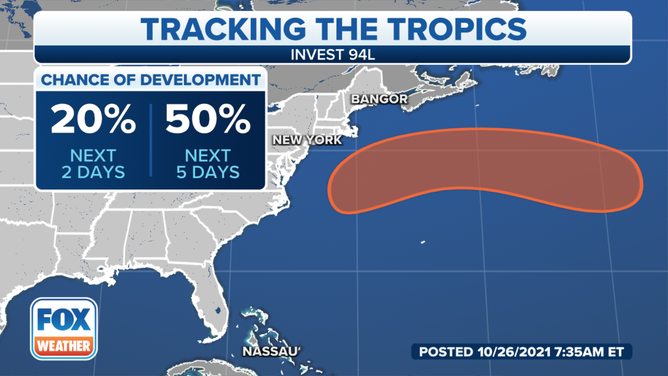
The Atlantic tropical outlook as of Tuesday, Oct. 26, 2021.
(FOX Weather)