Severe storms, flash flooding threaten areas from South to Ohio Valley through Tuesday night
The Ohio and Tennessee valleys have the highest risk of flash flooding
Flash flood reports in Alabama, Kentucky and North Carolina Tuesday
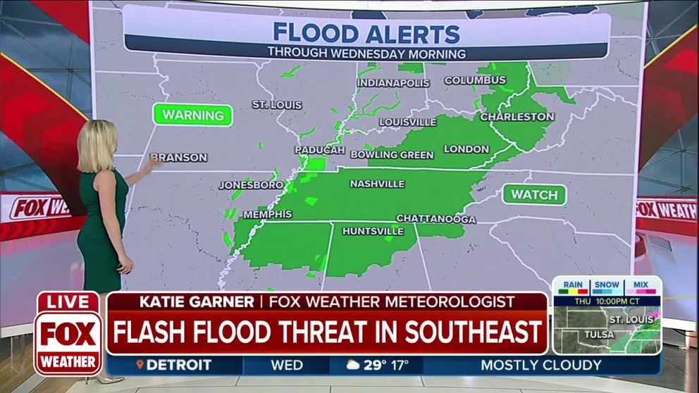
Flash flood reports in Alabama, Kentucky and North Carolina Tuesday. Alerts will remain in place for areas of the Southeast through Wednesday morning.
Severe thunderstorms and flash flooding will threaten areas from the South to the Ohio Valley through Tuesday night on the warm side of a winter storm tracking across the Midwest.
Severe storms initially fired up Monday night and early Tuesday and produced large hail across parts of North Texas.
FOX Weather Watcher Melisa LaPinta shared photos of golf-ball-sized hail in Frisco, Texas, about 3:30 a.m. Central time Tuesday morning.
WEATHER WIRE: MOST OF U.S. UNDER WEATHER ALERTS AS LARGE STORM CROSSES COUNTRY
The threat of severe storms Tuesday afternoon and evening will target parts of Middle Tennessee, northern Mississippi and northern Alabama.
Isolated tornadoes, damaging wind gusts and large hail are the main threats in this region.
CHECK YOUR WEATHER BINGO CARD: STORM BRINGING A LITTLE BIT OF EVERYTHING TO U.S.
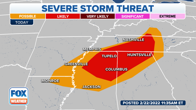
Severe storm threat on Tuesday, Feb. 22, 2022.
(FOX Weather)
Tuesday evening into the overnight hours, a second round of scattered severe thunderstorms is possible across parts of northern Mississippi and northern Alabama.
Damaging winds, hail and an isolated tornado or two are possible with this second round.
Flash flood threat in Ohio, Tennessee valleys
In addition to the severe weather, there's also a threat of flash flooding in the Ohio and Tennessee valleys.
Between 2 and 5 inches of rain could soak these regions through early Wednesday. Localized amounts up to 6 inches are not ruled out.
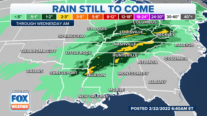
Rain forecast through early Wednesday, Feb. 23, 2022.
(FOX Weather)
The highest risk of flash flooding Tuesday and Tuesday night will be in parts of southern Kentucky, West and Middle Tennessee, northern Mississippi and northern Alabama, according to NOAA's Weather Prediction Center.
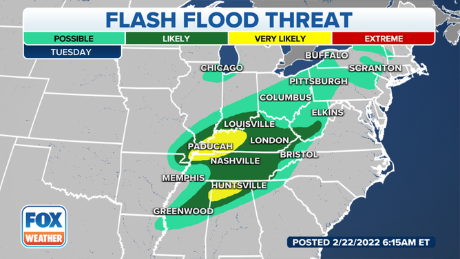
Flash flood threat on Tuesday, Feb. 22, 2022.
(FOX Weather)
Isolated flash flooding is also not ruled in parts of the Northeast, where 1 to 2 inches of rain could fall through Tuesday night, particularly across the western Pennsylvania ridges, the Poconos of northeastern Pennsylvania, the eastern Catskills and Adirondacks of New York and the Green Mountains of Vermont.
RAIN, MILD AIR MOVING INTO THE NORTHEAST BEFORE BIG TEMPERATURE CHANGES LATER THIS WEEK
Flood Watches have been issued by the National Weather Service from the Tennessee and Ohio valleys into western Pennsylvania, western and upstate New York and parts of northern New England.