Winter storm blanketed South in snow, rain for coastal Northeast
Heavy snow and ices storms knocked down trees and powerlines over the weekend making travel difficult.
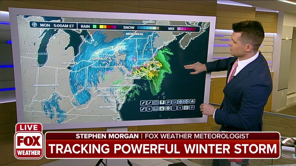
Heavy snow, rain continue as winter storm delivers final blow to the Northeast
A major winter storm that brought snow, ice, severe weather and strong winds to the eastern United States will finally move out of the Northeast and into Canada on Monday.
The weekend's winter storm that dropped over a foot of snow across the South and Mid-Atlantic states charged north up the eastern seaboard on Monday.
Areas near the coast saw heavy rain while snow piled up across the interior.
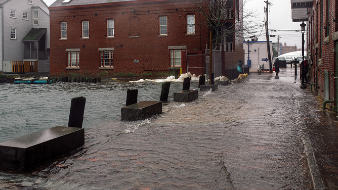
Flooding in Portland, Maine, on Monday.
(Ian MacLellan)
Areas along Lake Eerie could potentially see up to two feet of snow through Wednesday, including Cleveland, Ohio and Buffalo, New York. Lake-effect snow beginning Monday night into Tuesday will continue to drive up those snow totals for areas near Rochester, New York, according to the National Weather Service in Buffalo.
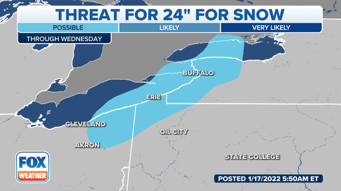
24 inches of snow is possible.
(FOX Weather)
Washington, Philadelphia and New York City started to dry out Monday morning, but winds gusted 20-40 mph.
High wind warnings and wind advisories were in effect through late Monday from eastern Virginia through Maine.
According to the National Weather Service in New York, southeast winds between 35 and 45 mph with gusts up to 65 mph were expected in southern New London County, Connecticut and southeast Suffolk and northeast Suffolk counties in New York.
(FOX Weather)
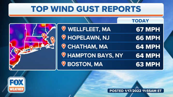
Massachusetts and Connecticut received heavy rain Monday morning and winds gusted over to 65 mph.
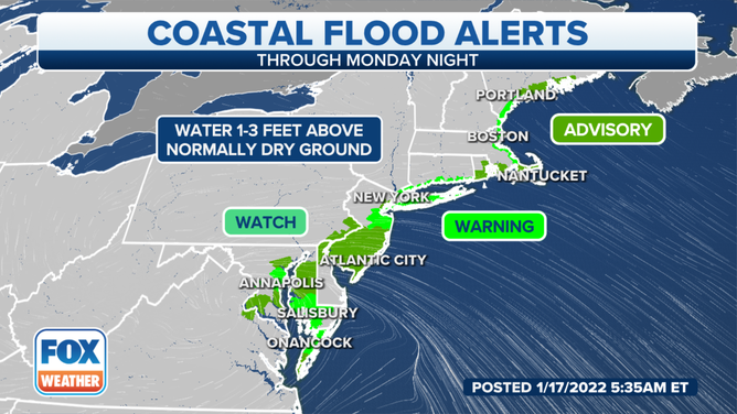
Northeast coastal flood alerts
(FOX Weather)
Unusually high tides also put coastal areas under Flood Watches and Warnings through Monday night.
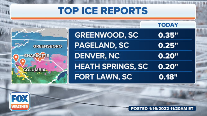
Monday morning commuters also faced some dangerous conditions across the mid-Atlantic where ice covered some roads after a night of freezing rain.
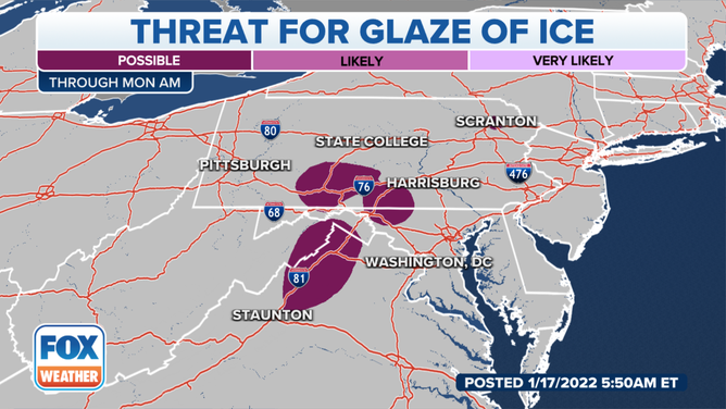
Threat for glaze
(FOX Weather)
SNOW, SLEET, FREEZING RAIN AND HAIL – WHAT'S THE DIFFERENCE?
States across the South and Mid-South that received weekend snow experienced some freezing roadways overnight. Georgia's Emergency Managers asked residents to stay off the roads Monday morning if possible.
Widespread ice and frozen slush was expected Monday morning, according to the NWS in Atlanta, and could continue through the middle of the week.
Ice glaze, wind gusts as high as 40 mph across higher elevations can be expected in upstate South Carolina, northeast Georgia and western North Carolina, according to the NWS.
POLICE RELEASE VIDEO IN HOPES THAT DRIVERS SLOW DOWN ON SLICK ROADS
Heavy snows through Monday
FOX Weather still forecasts 1-2 feet of snow across the Great Lakes, Upstate New York, Vermont and New Hampshire through Monday. Lake-effect snow will linger into Tuesday.
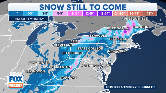
Snow still to come from the winter storm impacting the Northeast.
(FOX Weather)
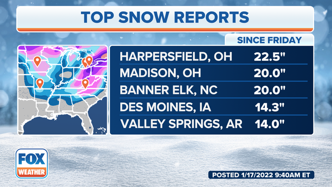
Sunday recorded record snowfall for the day for both Asheville, North Carolina (10 inches) and the Greenville-Spartanburg Airport, South Carolina (6.1 inches).
By mid-morning Monday, Harpersfield, Ohio, located northeast of Cleveland, had received more than 22 inches since Friday.
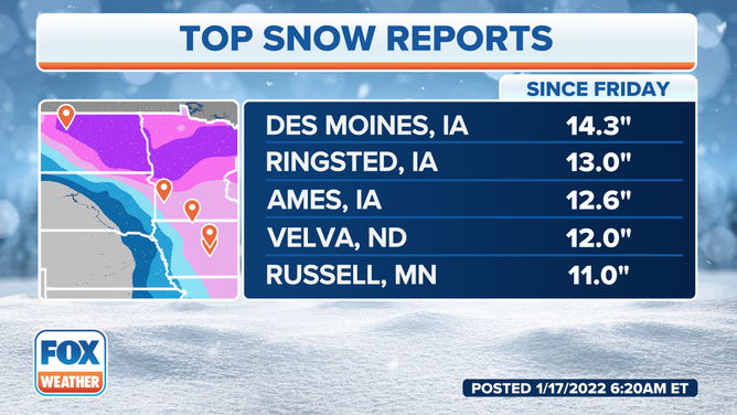
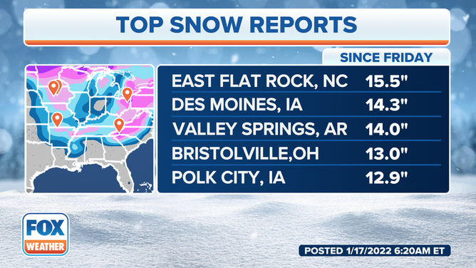
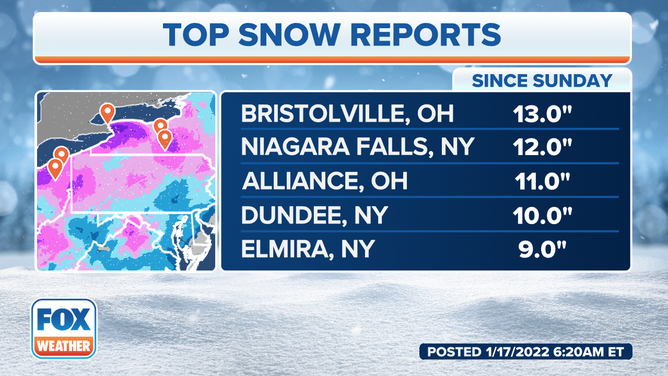
More snow and ice totals from the weekend:
![Top snow reports since Friday]() Image 1 of 5
Image 1 of 5Top snow reports since Friday ( )
![Top snow reports in the Mid West.]() Image 2 of 5
Image 2 of 5Top snow reports in the Mid West. ( )
![Top snow reports for the winter storm moving across the Northeast.]() Image 3 of 5
Image 3 of 5Top snow reports for the winter storm moving across the Northeast. ( )
![Northeast top snow reports]() Image 4 of 5
Image 4 of 5Northeast top snow reports ( )
![]() Image 5 of 5
Image 5 of 5( )
The same storm spawned several tornadoes across Florida.
FOUR TORNADOES TEAR THROUGH FLORIDA NEIGHBORHOODS, FLIP VEHICLES SUNDAY
More than 200,000 homes and businesses are still without power with a majority of the outages in North and South Carolina as of Monday morning, according to PowerOutage.us. Outages in New York, Connecticut, West Virginia and Pennsylvania are also being reported in the thousands.
Hazardous road conditions are delaying repairs, according to Duke Energy. As conditions improve later Monday the company said most customers should be restored by the end of the day in South and North Carolina.
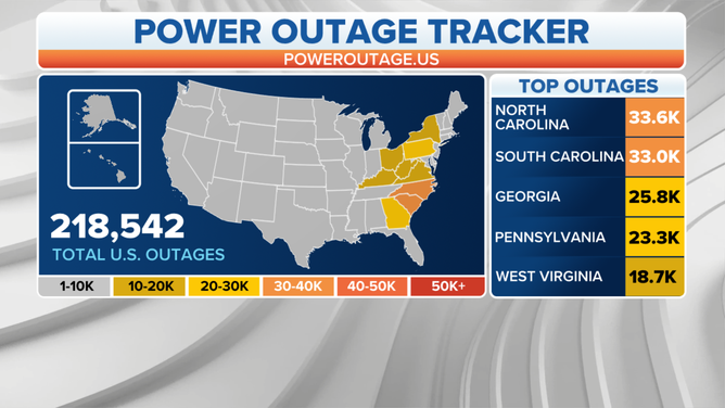
Power outages caused by the major winter storm as of Monday morning.
(FOX Weather)