Ian downgraded to post tropical cyclone, system expected to soak I-95 corridor through weekend
Ian downgraded to post tropical cyclone, system expected to soak I-95 corridor through weekend
Download the AppCoverage for this event has ended.
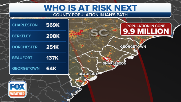
Live coverage of Ian for Friday, 09/30, has ended here. For continuing, live coverage head over to: Tracking Ian
The State of Florida has confirmed 23 deaths associated with Hurricane Ida but local authorities say the death count will go much higher.
Many of the deaths have been reported from Collier, Lee and Volusia counties.
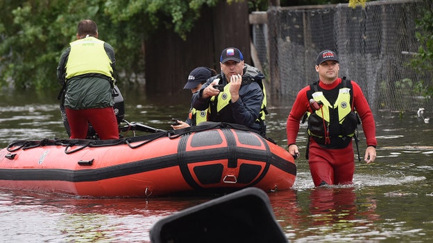
Search and rescue operations are still ongoing in Central and Southwest Florida.
Updates: Read more here
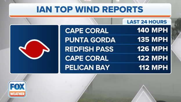
Highest wind gusts
Heavy delays were reported along Interstate 75 between Venice and Port Charlotte as evacuees encountered flooding along one of the main reentry routes.
The FOX Forecast Center said Ian dropped 19 inches of rain in North Port in just over two days.
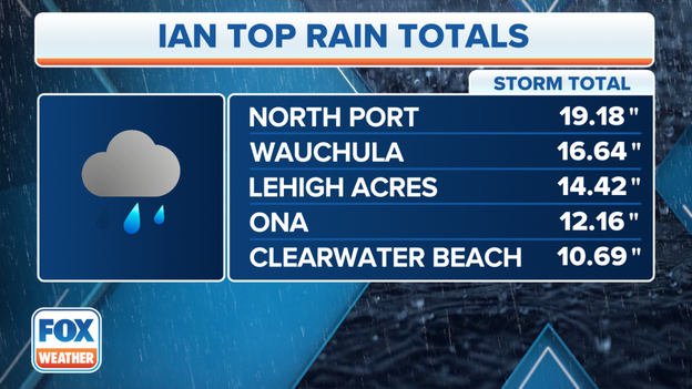
Rainfall estimates
The owners of the Tampa Bay Buccaneers announced on Friday a $1 million donation to help with Hurricane Ian relief efforts across the state.
"The destruction suffered in Southwest Florida and the damage inflicted throughout our state will be felt for some time," Buccaneers Co-Owner Darcie Glazer Kassewitz said in a statement. "It will take entire communities resiliently working together for an extended period, and our family is committed to aiding in the recovery. Our thoughts and prayers are with the countless people affected, the heroic first responders and all of those helping to keep others safe."
After the storm, the Buccaneers announced the team would play Sunday night's Week 4 game against the Kansas City Chiefs at Raymond James Stadium as originally scheduled.

Tracking Ian
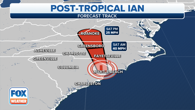
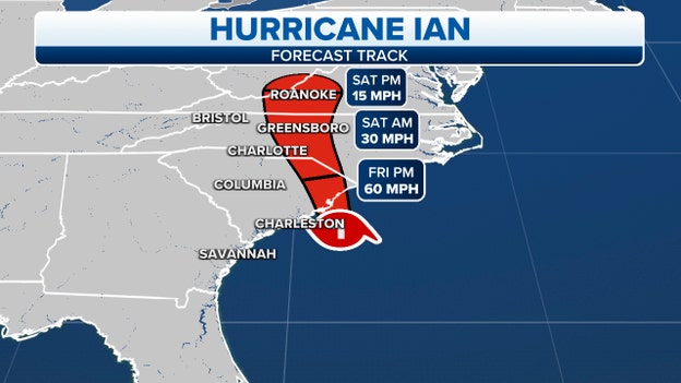
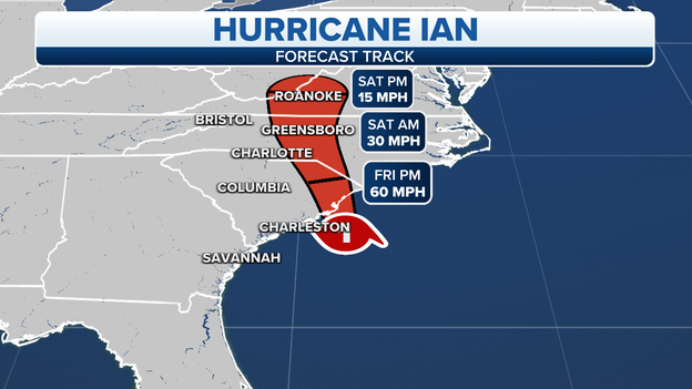
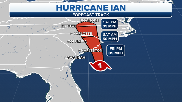
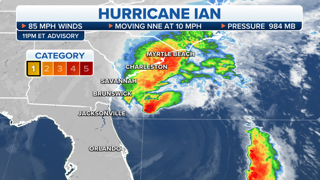
As of 8 p.m., Post-Tropical Cyclone Ian was located near the South Carolina-North Carolina border and had sustained winds of 60 mph.
Ian is expected to continue to weaken overnight and dissipate over central North Carolina or Virginia on Saturday
Tropical-storm-force winds extend outward up to 205 miles from the center.
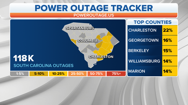
Utility companies are working in states across the Southeast to restore power as quickly as possible from Ian. At last count, over 2 million customers from Florida to Virginia were without power. The combination of wind and rain can cause trees with weak root systems to fall over, bringing down additional power lines. That is a concern for states with a heavy tree canopy.
Florida: 1,570,000+ (Decreasing trend)
Georgia: 16 (Decreasing trend)
South Carolina: 165,000 + (Decreasing trend)
North Carolina: 263,000+ (Growing trend)
Virginia: 52,000+ (Growing trend)
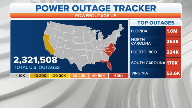
Power outage map
7 Ways to stay safe while using a generator: Learn more

Ian’s rains are quickly saturating the grounds of South Carolina and North Carolina, as the cyclone moves northward. If additional rain falls on already saturated grounds, the rainfall could lead to flooding.
The saturated grounds could also lead to more trees falling overnight.
The majority of a tree’s roots are in the first couple feet of the ground and when the soil because mushy the roots have less steady soil to secure the tree in place.
Wind gusts and in combination with rainfall can be detrimental to an area’s tree canopy.
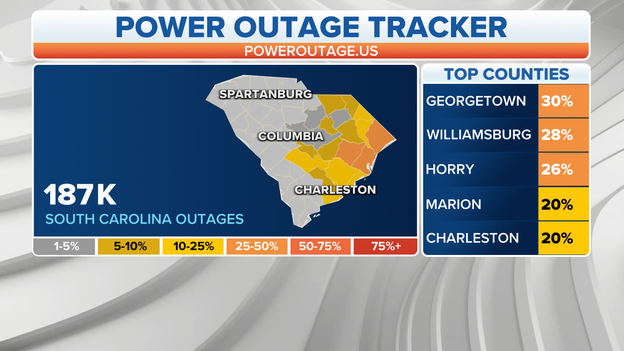
Power outages in South Carolina after Ian's landfall.
Power outages in South Carolina are growing to nearly 190,000 after Ian's landfall.
Georgetown, Horry and Williamsburg, South Carolina have the most outages as the storm is now over land and moving inland.
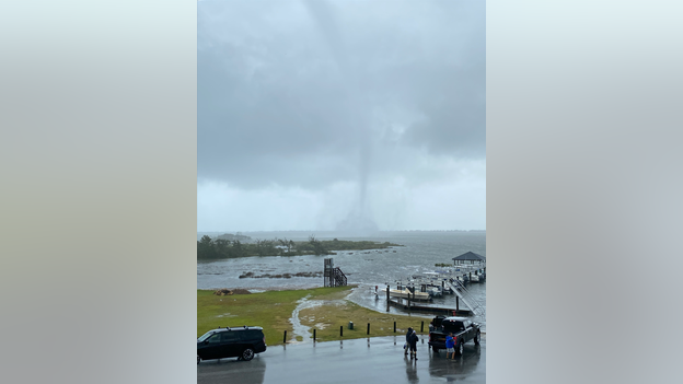
N.C. Waterspout
The National Weather Service captured photos of a waterspout in the area of Bogue Sound, south of Morehead City, N.C.
There was no reported damage by the waterspout around 2 p.m.
The threat for additional tornadoes or waterspouts will continue through the evening.
How you can prepare for a tornado: Learn more
Governor Ron DeSantis tours damage
Florida Governor Ron DeSantis is touring damage in St. Augustine, Florida from Hurricane Ian.
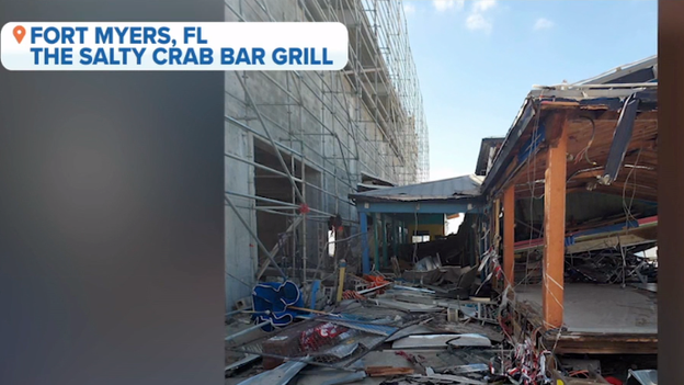
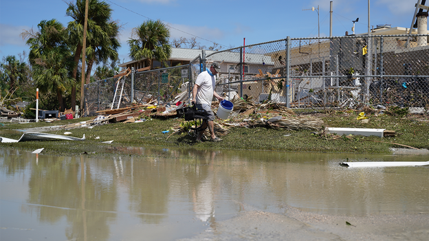
Hurricane Ian damages to the Salty Crab Bar and Grill in Fort Myers.
The businesses damaged or destroyed by Hurricane Ian in Southwest Florida will have long-lasting impacts to the community, including on the employees who lost their homes and employment.
Salty Crab and Grill Marketing Director Julia Cassino said 78 employees are left with just the clothes on their backs after the restaurant was totaled.

Tracking Ian
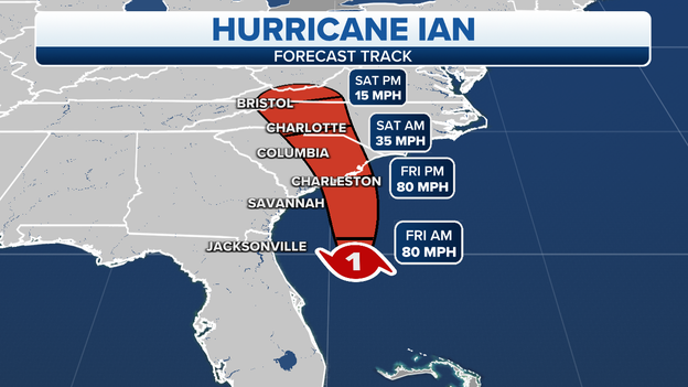
Hurricane Ian made landfall near Georgetown, South Carolina, on Friday afternoon and has weakened over the state.
Ian has sustained winds of 70 mph and that is expected to decrease through the evening.
Ian is moving north at 15 mph and is forecast to weaken rapidly over land.
A Storm Surge Warning remains in effect for parts of the North Carolina coast, as a storm surge of more than 4 feet is possible, which could make travel difficult.
Ian tracker: Where the system is heading next
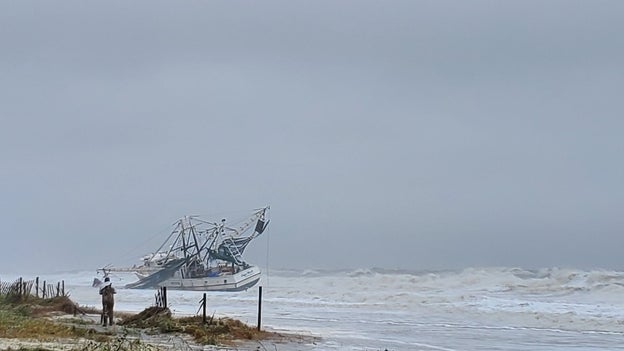
South Carolina shrimp boat
The rough seas of the Atlantic washed a large shrimping boat ashore in Myrtle Beach, South Carolina.
Police said that no one was aboard the boat when it broke free and drifted ashore.
Authorities advised everyone to stay off the beaches and out of the water due to the rough seas and continuing flooding.
Police did not say how or when the boat could be removed but encouraged beachgoers to stay away from the site.
Track Ian's movements: Click here
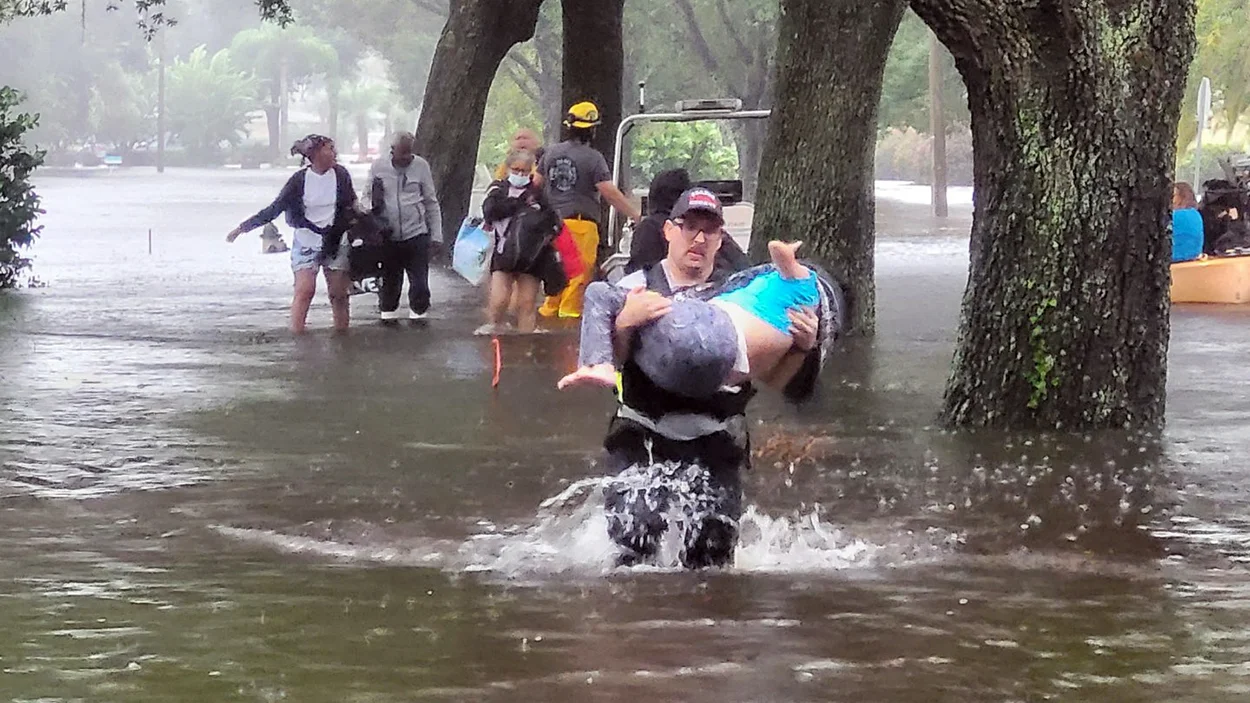
Police in Pawleys Island made water rescues on flooded roadways in South Carolina on Friday.
Video showed feet of storm surge inundating the island due to Hurricane Ida.
Storm surge of several feet is expected to continue through the evening as the onshore winds bring in parts of the Atlantic Ocean.
Storm surge forecast
Several roadways in Myrtle Beach, South Carolina are flooded due to the combination of rainwater and storm surge. Police said they’ve observed people risking their lives by driving through high water. Police shared video of an SUV passing through high water in the area of 3rd Ave South and Ocean Blvd.
Storm surge levels will slowly fall overnight and into the weekend as the center of Ian moves further inland and winds start to relax.
Watch impacts from Hurricane Ian live: Folly Beach, South Carolina
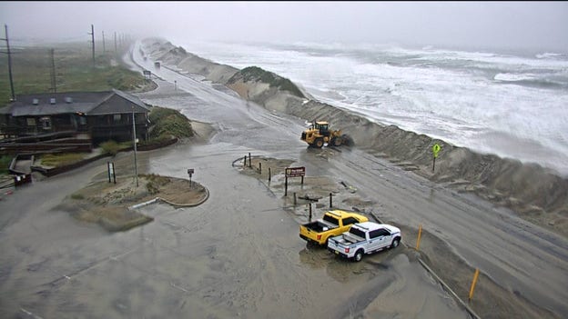
Outer Banks
The combination of drifting sand and overwash from the ocean is making travel difficult along the Outer Banks.
The state department of transportation reports there is standing water on some parts of state highway 12.
Increased water levels, especially at times of high tide, will continue to impact the islands through the weekend.
Flagler County Emergency Management
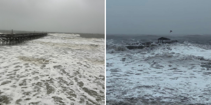
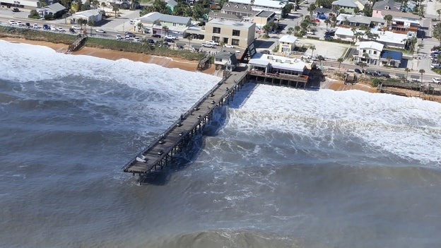
Clean-up is underway along Florida's east coast and Hurricane Ian's rough seas destroyed part of the Flagler County pier. The pier remains closed and beachgoers are advised to remain out of the water due to the continued rough seas and debris. Damage assessments are underway throughout the county.
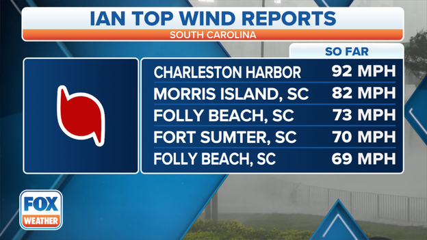
Top winds report in South Carolina. (Image: FOX Weather)
Top winds measured close to 100 mph before Hurricane Ian's landfall as reports continue to come in.
Murrells Inlet in South Carolina is seeing flooding after Hurricane Ian made landfall.
Storm surge is flooding Pawleys Island, South Carolina Photos from Pawley's Island Police show water surging down Springs Avenue.
"Tidal surge has lived up to predictions," Pawleys Island police said.
Already a pier at the island collapsed earlier in the afternoon due to rough surf.
According to the National Hurricane Center, Ian has made 4 total landfalls.
Cuba -- 4:30 a.m. ET on Tuesday, Sept. 27
Cayo Costa, Florida -- 3:05 p.m. ET on Wednesday, Sept. 28
Pirate Harbor, Florida-- 4:35 p.m. ET on Wednesday, Sept. 28
Georgetown, South Carolina -- 2:05 p.m. ET on Friday, Sept. 30
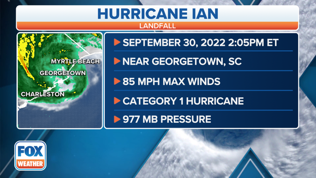
Hurricane Ian's South Carolina landfall stats
Hurricane Ian has made landfall near Georgetown, South Carolina, as of 2:05 p.m. ET, according to the National Hurricane Center.
Ian arrived as a Category 1 hurricane with 85 mph wind and a central pressure of 977 millibars.
It is Hurricane Ian's final landfall after striking western Cuba on early Tuesday and coming ashore in southwestern Florida Wednesday -- first at Cayo Costa at 3:05 p.m. ET, then Pirate Harbor 90 minutes later.
Hurricane Ian is moving north at 15 mph and is forecast to weaken rapidly over land, then transition into a post-tropical cyclone on Friday night. Ian is expected to dissipate over western North Carolina or Virginia by late Saturday.
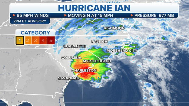
The current status of Hurricane Ian as of 2 p.m. Eastern time. (FOX Weather)
In the 2 p.m. Eastern time advisory, the National Hurricane Center said the center of Hurricane Ian was about to make landfall in South Carolina.
Life-threatening storm surge, damaging winds and flash flooding are already lashing the Carolinas as Ian's eyewall scrapes the coastline. The eyewall of a hurricane contains the most intense winds.
Ian remains a Category 1 hurricane with maximum sustained winds of 85 mph. It is currently located 55 miles east-northeast of Charleston, South Carolina, and is moving northward at 15 mph.
Hurricane Ian is forecast to weaken rapidly after making landfall and then will transition into a post-tropical cyclone on Friday night. Ian is expected to dissipate over western North Carolina or Virginia by late Saturday.
This NOAA/NASA Suomi NPP satellite animation shows where power outages remained in Florida after Hurricane Ian as of Thursday night.
"Compared to the same image from earlier this year, you can see the difference in nighttime lights," the NOAA Satellite and Information Service (NESDIS) wrote on Twitter.
As of Friday afternoon, more than 1.8 million people in Florida remained without power, according to PowerOutage.US.
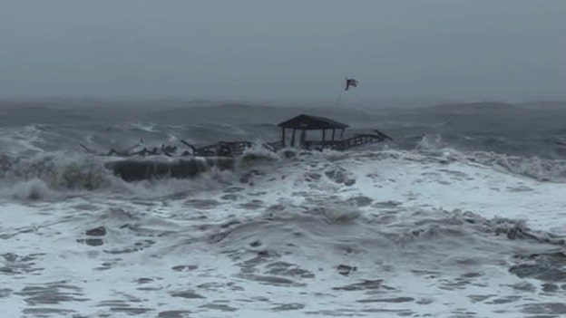
Photo: Pawley's Island Police
Hurricane Ian has wiped out a pier in South Carolina.
The end of Pawleys Island pier collapsed as Hurricane Ian neared landfall Friday afternoon, according to Pawleys Island Police.
The damaged pier is now floating south.
Video from South Carolina shows Hurricane Ian's fast winds moving water quickly around South Island Landing.
(FOX Weather)
Over 100,000 customers are without power in South Carolina due to Hurricane Ian.
Due to current weather conditions in Charleston, South Carolina, the police department said their officers are now sheltering in place at area police substations.
"They will, on a limited capacity, respond to critical calls only until further notice," the department said.
Isle of Palm Fire Department and Charleston County EMS also have both temporarily suspended service due to the weather.
Operations at Florida's spaceport are returning to normal after Hurricane Ian's rampage throughout the state.
NASA and SpaceX are now targeting Wednesday, Oct. 5, to launch an American, Japanese and Russian astronaut crew to the International Space Station.
If the current schedule holds, the Crew-5 mission will launch on SpaceX's Falcon 9 rocket and Crew Dragon spacecraft from Kennedy Space Center launchpad 39A at noon EDT. Backup launch dates are available on Oct. 7 and possibly Oct. 6-9, pending a review.
To read more from FOX Weather's Emilee Speck, click on the link below.

Pawleys Island is feeling the impacts from Hurricane Ian.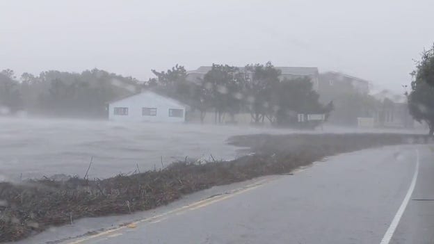
Waves, water and debris cover half of a roadway in Pawleys Island, South Carolina.
The Horry County Police Department in South Carolina said road conditions are deteriorating.
"If you don’t have to travel, stay off the roads, "the department said in a tweet. "Ian will pass and any travel can happen AFTER the storm. Please, for your safety and the safety of others, move indoors and stay indoors."
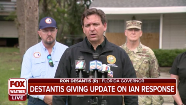
Gov. Ron DeSantis is providing an update on Florida's recovery in the aftermath of Hurricane Ian.
Governor Henry McMaster holds a media briefing with state emergency management officials to update the public on Hurricane Ian's impact on South Carolina.
Charleston’s highest storm surge occurred in 1989 with the landfall of Hurricane Hugo.
A tide gauge in the harbor reported a water level of 12.52 feet. The National Weather Service says when the gauge reaches 8 feet, widespread flooding occurs in downtown Charleston with numerous roads flooded and impassable.
The NWS expects the gauge to reach a level of 8.7 feet around the time of Ian’s landfall, which will cause significant issues for Charleston and the Low Country.
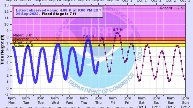
Charleston Harbor Water Gauge (NOAA)
Savannah’s highest crest happened during Hurricane Matthew of 2016. The tidal gauge reached 12.56 feet during the storm.
The NWS said they don’t expect water levels from Ian to reach Matthew-like levels, but they could be significant. The NWS is forecasting a water height of 10.7 feet along the mouth of the Savannah River.
At 10.5 feet, major coastal flooding occurs. Flooding will likely cause the closure of local roadways, and several coastal communities will be temporarily cut off from the mainland. On Tybee Island, a level over 10 feet has previously led to widespread flooding, with several properties impacted.
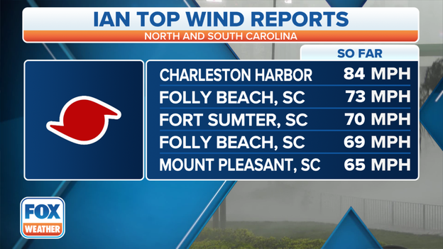
Top wind reports from Hurricane Ian. (FOX Weather)
A weather station at Charleston Harbor in South Carolina has reported a wind gust of 84 mph as Hurricane Ian begins to move onshore.
Gusts of 70-plus mph have also been clocked at Folly Beach and Fort Sumter in South Carolina.
Hurricane Ian will be making landfall soon along the South Carolina coast.
A Tornado Watch has been issued for eastern North Carolina, northeastern South Carolina and southeastern Virginia until 10 p.m. Eastern time.
A few tornadoes are possible in these areas through Friday evening before the threat shifts northward and focuses mainly on southeastern Virginia overnight through early Saturday morning.
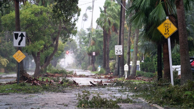
Storm debris litters a street in the wake of Hurricane Ian September 28, 2022 in Sarasota, Florida. (Sean Rayford/Getty Images)
The Sarasota County Sheriff's Office provided an update on the two deaths in an unincorporated part of the county that appear to be related to Hurricane Ian's catastrophic weather event.
Both incidents involve residents who relied on oxygen machines that were disabled due to power loss during the storm.
"One individual, a 94-year-old male, lives in the Palmer Ranch area and the other, an 80-year-old female, in north Sarasota," the sheriff's office said in a tweet.
Hurricane Ian is nearing its final landfall along the South Carolina coast.
Life-threatening storm surge, damaging winds and flooding rainfall are now moving onshore in association with Ian's eyewall, which contains the hurricane's strongest winds.
Landfall is expected soon in South Carolina. Stay with America's Weather Team for the latest updates.
There have been 12 "I" storms retired in the Atlantic – 10 of them since 2001. And now, Ian appears to be the next potential candidate for retirement after the Category 4 hurricane caused catastrophic damage in Florida earlier this week.
In fact, more names starting with the letter "I" have been retired than any other letter used for Atlantic hurricane names.
So will we see another "Ian" in the Atlantic in 2028, when the 2022 list of names is used again in the six-year rotation? Click the story at the top of this post to learn more.
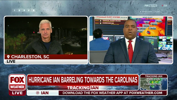
FOX News Correspondent Molly Line is in Charleston, South Carolina.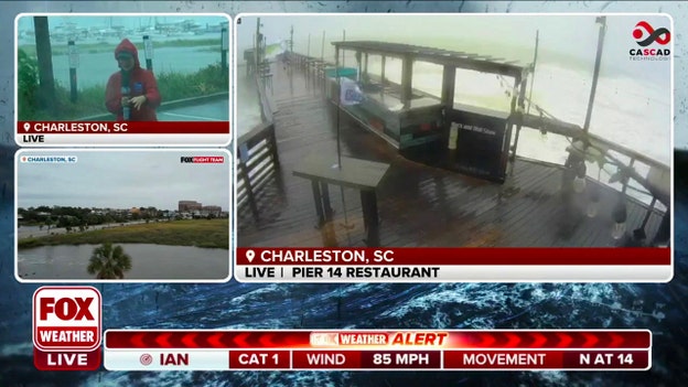
Click here to watch as FOX News Correspondent Molly Line reports from Charleston, South Carolina, where Hurricane Ian is beginning to move in.
Tracking Ian (FOX Weather)
Tropical Storm Colin was about as weak as you will ever see a named storm. Sustained winds briefly reached 40 mph, but its rainfall was more impressive. Despite being a weak tropical cyclone, Colin produced more than half a foot of rain that quickly flooded some streets in downtown Charleston.
Hurricane Ian will be much stronger at landfall. The NHC expects winds upwards of 80 mph, a storm surge of between 4 – 7 feet and rains that could be between 6 – 12 inches.
Video shows conditions in Isle of Palms, South Carolina as Hurricane Ian approaches.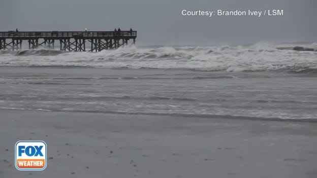
Winds picking up this morning as Hurricane Ian approaches the South Carolina coast.
Click on the image above or this link to watch as Ian approaches Isle of Palms, South Carolina, and street flooding in Charleston.
The projected path and intensity of Hurricane Ian. (FOX Weather)
Hurricane Ian has maintained its Category 1 intensity and still has maximum sustained winds of 85 mph as of 11 a.m. Eastern time.
Ian is currently centered about 60 miles east-southeast of Charleston, South Carolina, or 120 miles south-southwest of Cape Fear, North Carolina. The hurricane is now accelerating a little faster toward the north at 14 mph.
Hurricane Ian is expected to remain about the same strength through its landfall along the South Carolina coast Friday afternoon, then it will weaken and rapidly transition into a post-tropical cyclone Friday night. Ian should dissipate over western North Carolina or Virginia by late Saturday.
Sustained tropical-storm-force winds (39-plus mph) and some hurricane-force gusts (74-plus mph) are already occurring along parts of the Georgia, South Carolina and North Carolina coasts.
A sustained wind of 62 mph and a gust to 87 mph were recently reported at an elevated WeatherFlow station on Winyah Bay Range in South Carolina.
Hurricane-force winds are expected to spread along the rest of the South Carolina coast and portions of the southeastern North Carolina coast soon. Hurricane-force winds are also possible farther north along the North Carolina coast Friday afternoon.
Life-threatening storm surge is also expected to arrive soon along the coastlines of the Carolinas and Georgia.
A storm surge of 4 to 7 feet is predicted along parts of the South Carolina coast from Isle of Palms to the South Carolina-North Carolina border. A 3- to 5-foot surge is forecast from the South Carolina-North Carolina border northeastward to Cape Fear, North Carolina.
Farther south, a storm-surge inundation of 2 to 4 feet is expected from the Georgia-South Carolina border to Isle of Palms, South Carolina. This includes the city of Charleston, South Carolina.
Hurricane Ian has strengthened to a Category 1 storm threatening to bring life-threatening storm surge and dangerous winds. Ian is forecast to make landfall in South Carolina today.
FOX Weather is streaming live video from cameras in Ian’s path on YouTube. Watch our stream in the player above.
Charleston, South Carolina, prepares for Hurricane Ian to make landfall.
Hurricane Ian has South Carolina in its sight and is expected to make landfall as a Category 1 storm today.
The storm is forecast to produce damaging winds for the Carolinas and could create significant flooding in coastal and low-lying areas.
Click here to watch as Ian moves in on Charleston, South Carolina seawall.
Tropical Cyclone Impacts on South Carolina (NOAA)
The Palmetto State sees tropical weather impacts nearly every season but the last hurricane to make a direct landfall was Hurricane Matthew. Matthew made landfall as a Category 1 storm on October 8, 2016, near McClellanville, South Carolina. Surge impacts were greater than a minimal hurricane because the storm was in the process of weakening from a Category 3.
While Matthew only scraped the South Carolina coast, it brought heavy rains to the region and was responsible for 25 deaths, according to the National Hurricane Center. Damage from the storm was estimated at $10.3 billion.
Take a look at this marina in Fort Myers, Florida, that is in disarray following Hurricane Ian.
FOX Weather's Robert Ray continues to survey the damage in Fort Myers where vessels were pushed onto shore from Hurricane Ian's storm surge.
Orange County Fire rescue unit members work in a flooded neighborhood in the aftermath of Hurricane Ian on September 29, 2022 in Orlando, Florida. (Paul Hennessy/Anadolu Agency via Getty Images)
A New Smyrna Beach-area man lost his life Thursday night after he fell and was unable to escape rising floodwaters in his home.
Deputies in a high-water vehicle responded to 1994 Lake Drive, New Smyrna Beach, about 10:30 p.m. as heavy floods saturated the area. The area was inaccessible by standard patrol vehicles, with water in the neighborhood at about waist level.
The 67-year-old victim and his wife were on a list to be rescued by high-water crews. Before the rescue crew arrived, the victim fell inside the home and could not get up before the water level rose over him, deputies said.
Rescuers performed life-saving measures but were unable to revive the victim. He was pronounced deceased on scene.
His wife and two dogs in the house were taken to a storm shelter. A deputy also recovered a third dog from the home and transported it to an animal shelter.
The death was the second in Volusia County during Hurricane Ian, with the first happening about 1 a.m. Thursday in Deltona, where a 72-year-old man fell in a canal behind his home during the storm.
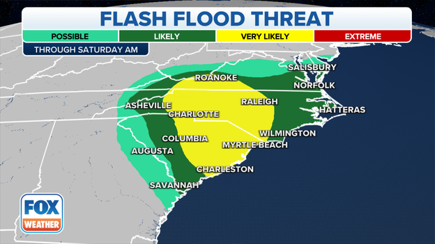
The flash flood threat for Friday. (FOX Weather)
Hurricane Ian is moving north toward the South Carolina coastline and is expected to make its final landfall on Friday afternoon in South Carolina.
High winds and flooding rains are expected as Ian approaches the coast and moves inland.
Between 4 and 8 inches of rain is predicted in northeastern South Carolina, with localized totals up to 12 inches possible.
Areas from central South Carolina into North Carolina and southern Virginia could pick up 3 to 6 inches of rain, with isolated amounts as high as 8 inches across northwestern North Carolina and southwestern Virginia.
Flash flooding will likely be widespread across this region.
Click here to learn more about flash flooding and what you should do when Flash Flood Warnings are issued.
Breathtaking video of Hurricane Ian's destruction shows shreds of wood where homes once were, roads look like rivers and boats in mangroves.
Lee County Sheriff Carmine Marceno described it as "homes thrown away like little toys." He said the Fort Myers pier and its Times Square is "no more."
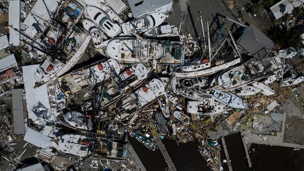
An aerial picture taken on September 29, 2022 shows piled up boats in the aftermath of Hurricane Ian in Fort Myers, Florida. (RICARDO ARDUENGO/AFP via Getty Images)
Florida Division of Emergency Management Director Kevin Guthrie spoke to reporters on Friday during an update with Florida Gov. Ron DeSantis.
He detailed the total number of fatalities from Hurricane Ian and broke it down county by county.
"We have one confirmed fatality in Polk County. We have 12 unconfirmed fatalities in Charlotte County. We have eight unconfirmed fatalities in Collier County," he said.
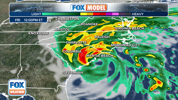
The forecast from the exclusive FOX Model for 12 p.m. Eastern on Friday.
The exclusive FOX Model shows Hurricane Ian moving onshore in South Carolina Friday afternoon, likely as a Category 1 hurricane.
High winds, life-threatening storm surge and flooding rainfall are all expected along the Southeast coast from Georgia up through the Outer Banks of North Carolina.
Click here to read more about the forecast for Hurricane Ian's final chapter in the Carolinas and Georgia.
You can track Hurricane Ian as it heads for the South Carolina coast using these maps.
Florida Gov. Ron DeSantis is providing an update on recovery efforts in the aftermath of Hurricane Ian's landfall earlier this week.
FOX Weather Hurricane Specialist Bryan Norcross explains that damaging winds and life-taking storm surge from Hurricane Ian are heading to the South Carolina coast this morning, and more torrential rain will come with the peak winds around landfall.
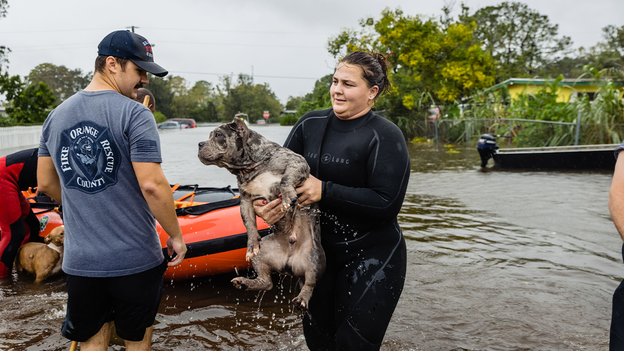
First responders have been saving beloved pets from floodwaters in Orange County, Florida. (Photo: twitter.com/OrangeCoFL)
While countless people are being rescued in the aftermath of Hurricane Ian in Florida, pets are having their lives saved as well.
Photos posted to Twitter show rescuers saving beloved pets from the rising floodwaters in Orange County, Florida.
While the Carolinas will not see the full force of Hurricane Ian the way Florida did, state officials warn residents that they could see high winds, storm surge, rain, flash flooding and even tornadoes into the start of the weekend.
Hurricane Ian will make its final landfall in South Carolina Friday afternoon after producing catastrophic damage earlier this week in Florida, where at least 11 people were killed.
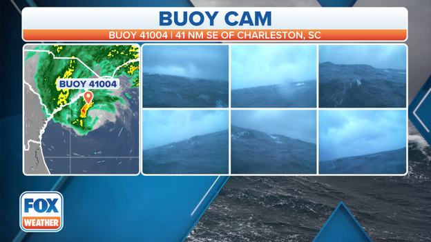
Hurricane-force wind gust reported off the coast of South Carolina
A buoy located about 41 nautical miles off the coast of Charleston, South Carolina, reported a hurricane-force wind gust of 74 mph on Friday morning.
Hurricane Ian is creeping closer to sore, and is expected to make its final landfall on Friday afternoon.
The South Carolina Emergency Management Division announced Friday morning that the state’s Emergency Operations Center has now been fully activated as Hurricane Ian approaches.
In addition, all agency personnel have been activated.
Hurricane Ian is expected to make landfall in South Carolina on Friday afternoon.
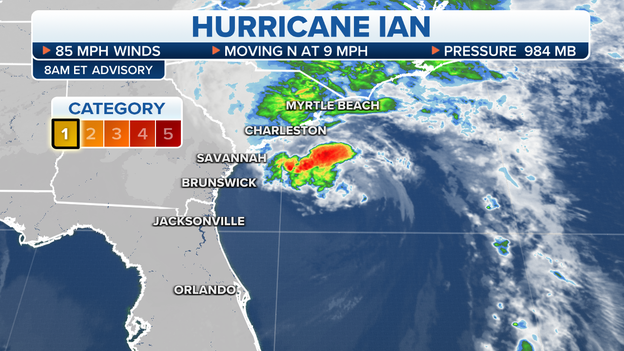
The latest status of Hurricane Ian as of 8 a.m. Eastern time. (FOX Weather)
Hurricane Ian has maintained its Category 1 intensity and still has maximum sustained winds of 85 mph as of 8 a.m. Eastern time.
Ian is currently centered about 105 miles south-southeast of Charleston, South Carolina, or 185 miles south-southwest of Cape Fear, North Carolina, and is crawling toward the north at only 9 mph.
Little change in strength is expected before Ian reaches the South Carolina coast Friday afternoon.
Tropical-storm-force winds (39-plus mph) are already occurring along parts of the Georgia, South Carolina and North Carolina coasts.
A sustained wind of 40 mph and a gust to 58 mph were recently reported at a WeatherFlow station on Fort Sumter Range Front Light in South Carolina.
Hurricane-force winds (74-plus mph) are expected to begin along the South Carolina coast and portions of the southeastern North Carolina coast by Friday afternoon. Hurricane-force winds are also possible farther north along the North Carolina coast later in the afternoon.
A storm surge of 4 to 7 feet is predicted along the South Carolina coast, including the city of Charleston. A 3- to 5-foot surge is forecast from the South Carolina-North Carolina border to Cape Fear, North Carolina. A storm surge of 3 to 5 feet is also expected from the Savannah River to Edisto Beach in South Carolina.
Lieutenant Gregory Bueno with the Florida Highway Patrol spoke with FOX Weather meteorologist Britta Merwin about search and rescue efforts taking place across Florida after Hurricane Ian made landfall on Wednesday.
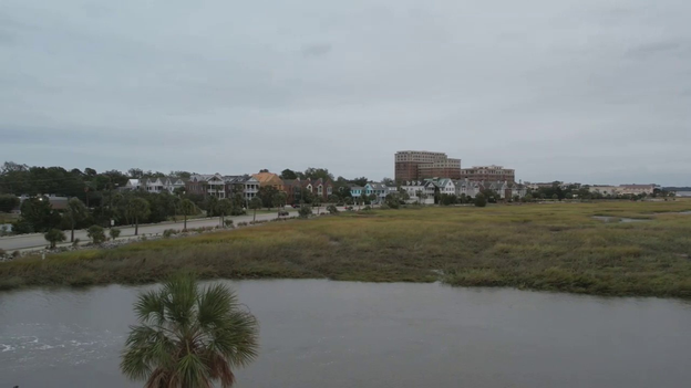
FOX Flight Team drone video shows calm before the storm in Charleston, South Carolina
This video shot by the FOX Flight Team shows the calm before the storm in Charleston, South Carolina.
Hurricane Ian is expected to make a final landfall in South Carolina after coming ashore in southwestern Florida as a Category 4 hurricane on Wednesday.

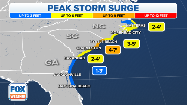
The peak storm surge forecast for Hurricane Ian. (FOX Weather)
Hurricane Ian is forecast to produce a life-threatening storm surge along the South Carolina coast, where the storm is expected to make landfall on Friday.
An inundation of 4 to 7 feet is predicted from Edisto Beach to the South Carolina-North Carolina border. This includes the city of Charleston, South Carolina.
Here's the forecast for the rest of the Southeast coast as Hurricane Ian approaches:
- South Carolina-North Carolina border to Cape Fear, North Carolina: 3 to 5 feet
- Savannah River to Edisto Beach in South Carolina: 3 to 5 feet
- Flagler/Volusia County line in Florida to the Georgia-South Carolina border: 2 to 4 feet
- Cape Fear River in North Carolina: 2 to 4 feet
- St. Johns River in Florida: 2 to 4 feet
- East of Cape Fear to Duck in North Carolina, including the Pamlico and Neuse rivers: 2 to 4 feet
- Patrick Air Force Base to the Flagler/Volusia County line in Florida: 1 to 3 feet
- Albemarle Sound in Georgia: 1 to 2 feet
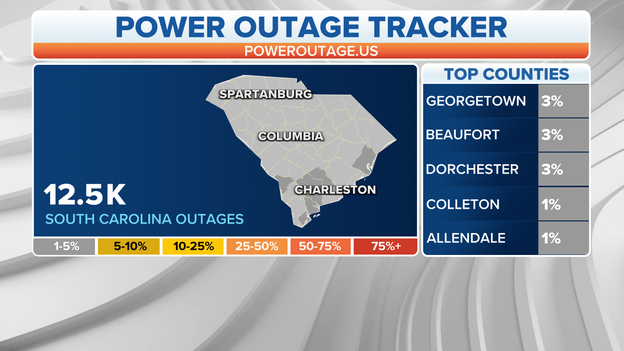
More than 12,000 power outages reported in South Carolina so far.
Hurricane Ian is approaching the South Carolina coast, and power outages are starting to climb as a result.
As of Friday morning, more than 12,000 outages have been reported and that number is expected to climb as Ian moves closer to shore and eventually makes a final landfall.
From Birth to monster: Watch Hurricane Ian’s journey from the Caribbean Sea to Florida landfall
In this video, FOX Weather meteorologist Ian Oliver shows us amazing images of Hurricane Ian’s journey from the Caribbean Sea through landfall along Florida’s southwestern coast.
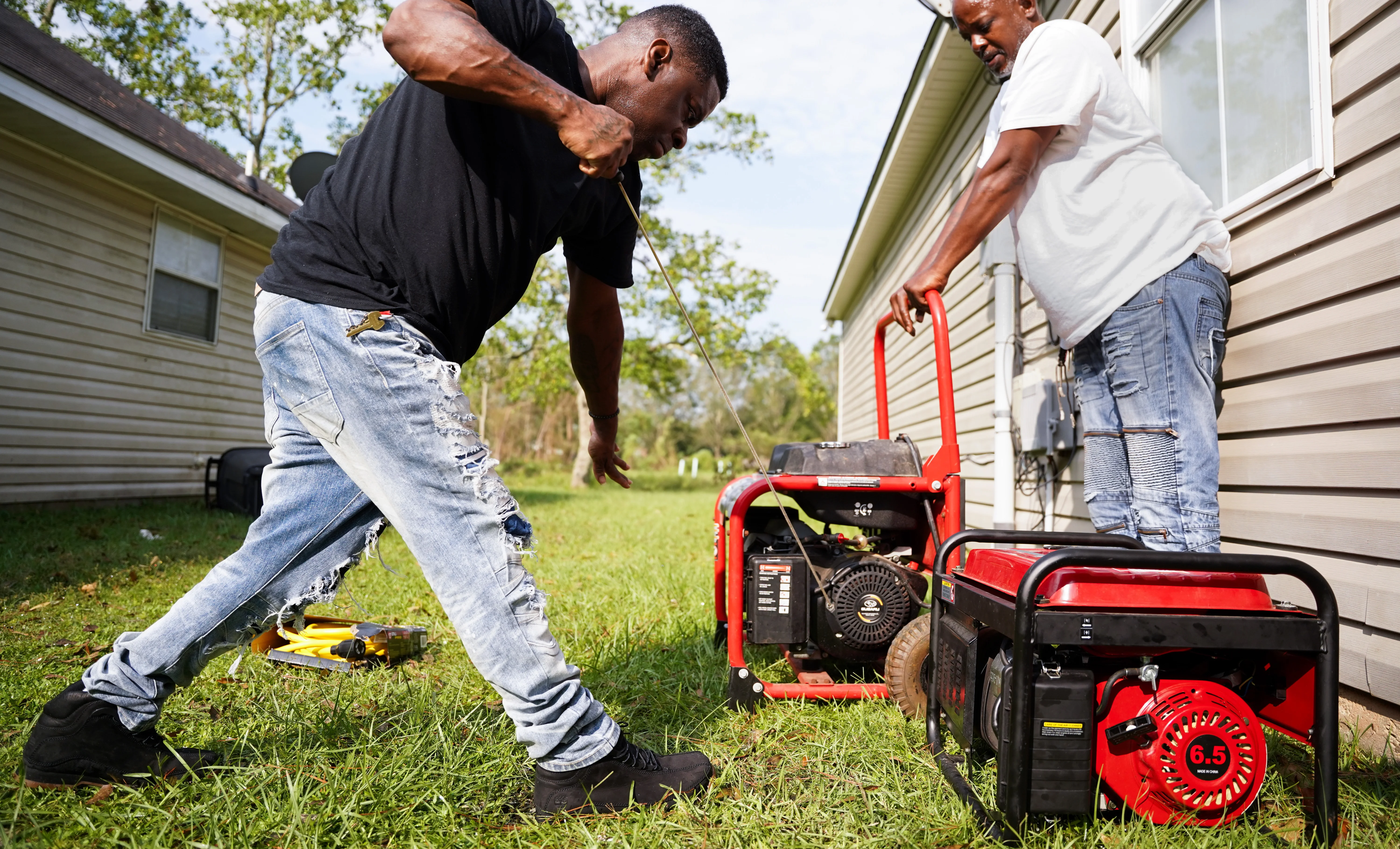
Hurricane Ian knocked out power to millions of customers after making landfall in southwestern Florida and spinning its way across the state.
However, generators can be dangerous if safety precautions aren't met.
The article above includes seven ways to make sure you stay safe while using a generator.
The Charleston Police Department announced that roads have been closed in the city as flooding begins an advance of Hurricane Ian.
Ian is expected to make a final landfall along the coast of the Carolinas on Friday afternoon.
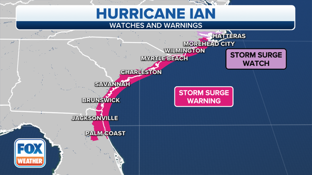
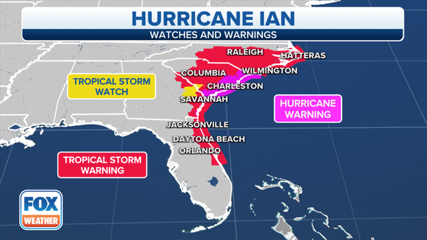
Storm Surge Watches and Warnings are in effect from Florida to North Carolina
Storm Surge Watches and Warnings have been issued from Florida to the North Carolina coast.
A storm surge between 4-7 feet is expected along the South Carolina coast from Charleston to Myrtle Beach.
This is because Hurricane Ian is approaching the region and is expected to make a final landfall along the Carolina coast.
A Flash Flood Warning has been issued for the Charleston, South Carolina, area until noon.
Nearly 250,000 people are included in this warning.
In this video, a large boat is seen resting on a street after it was forced inland during Hurricane Ian.
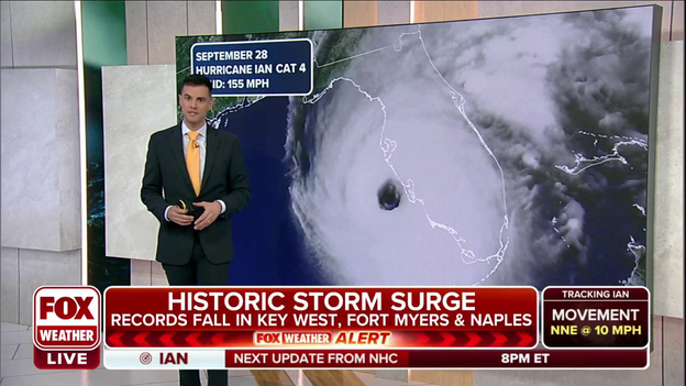
Widespread damage has been reported across the Fort Myers area after Hurricane Ian made landfall in the southwestern part of the state as a Category 4 hurricane with winds of 150 mph.

Nick Underwood, NOAA Hurricane Hunter Engineer, recalls traveling through the eye of Hurricane Ian in the Lockheed WP-3D Orion.
“Our flight on Wednesday morning was the most turbulent flight that I’ve been on in my six years of chasing hurricanes with NOAA,” Nick Underwood said.
Check out this video where he describes more of his wild ride.
Hurricane Ian is forecast to make landfall between the Beaufort, Charleston and Georgetown areas in South Carolina. (FOX Weather)
Ian is forecast to make landfall in South Carolina as a Category 1 hurricane on Friday.
According to Colorado State University tropical scientist Phil Klotzbach, Matthew in 2016 was the last hurricane to make landfall in South Carolina.
Klotzbach also noted that the most recent landfalling South Carolina hurricane that had previously made landfall in Florida as a hurricane was Charley in 2004, which made landfall in the same location and at the same intensity as Ian on Wednesday.
Click here to read more about the stunning comparisons between Hurricane Ian and Hurricane Charley.
Fox News Correspondent Doug Luzader is in Charleston, South Carolina, where they are starting to feel some impacts from Hurricane Ian.
Fox News Correspondent Doug Luzader is in Charleston, South Carolina, and joined FOX Weather meteorologist Jason Frazer on Friday morning.
In this video, Luzader tells Frazer that the effects of Hurricane Ian are staring to be felt across the region.

Hurricane Ian is expected to make a final landfall along the Carolina cost on Friday.
As the hurricane nears, it's important to have emergency supplies in case of power outages and other emergencies.
The article above has tips on what to include in your emergency kits.
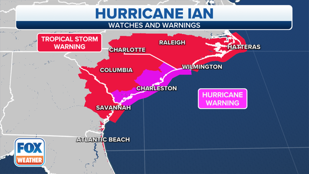
Hurricane Warnings and Tropical Storm Warnings remain in effect across the Carolinas as Hurricane Ian nears.
Hurricane Warnings and Tropical Storm Warnings remain in effect across the Carolinas as Hurricane Ian pushes closer to the coast.
Parts of eastern Georgia, including Savannah, is also included in the Tropical Storm Warning.
Hurricane Ian first made landfall in southwestern Florida on Wednesday as a powerful Category 4 hurricane with winds of 150 mph.
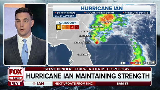
FOX Weather meteorologist Steve Bender breaks down the 5 a.m. advisory on Hurricane Ian
FOX Weather meteorologist Steve Bender breaks down the latest information on Hurricane Ian as it pushes closer to the South Carolina coast for another landfall.
The projected path and intensity of Hurricane Ian. (FOX Weather)
Hurricane Ian has maintained its Category 1 intensity and still has maximum sustained winds of 85 mph as of 5 a.m. Eastern time.
Ian is currently centered about 145 miles south-southeast of Charleston, South Carolina, or 225 miles south-southwest of Cape Fear, North Carolina, and is crawling toward the north-northeast at only 9 mph.
Little change in strength is expected before Ian reaches the South Carolina coast later Friday.
Tropical-storm-force winds (39-plus mph) are already occurring along parts of the Georgia, South Carolina and North Carolina coasts.
A sustained wind of 38 mph and a gust to 52 mph were recently reported at the Hilton Head Airport in South Carolina. An elevated WeatherFlow station at the Winyah Bay Range Light in South Carolina measured a sustained wind of 49 mph and a gust to 71 mph during the past couple of hours.
Hurricane-force winds (74-plus mph) are expected to begin along the South Carolina coast and portions of the southeastern North Carolina coast on Friday afternoon. Hurricane-force winds are also possible farther north along the North Carolina coast by later Friday afternoon.
A storm surge of 4 to 7 feet is predicted along the South Carolina coast, including the city of Charleston. A 3- to 5-foot surge is forecast from the South Carolina-North Carolina border to Cape Fear, North Carolina. A storm surge of 3 to 5 feet is also expected from the Savannah River to Edisto Beach in South Carolina.
A general view from the site after Hurricane Ian left Florida on Thursday following making landfall as a devastating Category 4 hurricane, on September 29, 2022 in Florida, United States. Widespread catastrophic damage has been left in much of southwestern Florida as 2.6 million people continue to lack power and thousands remain stranded. (Photo by Lokman Vural Elibol/Anadolu Agency via Getty Images)
A boil water notice has been implemented in Lee County, including the city of Fort Myers.
This applies to water being consumed for drinking, washing dishes, brushing teeth, etc.
Hurricane Ian is less than 200 miles from the South Carolina coast and landfall is expected within the next 12 hours.
Nick Underwood, NOAA Hurricane Hunter Engineer, recalls traveling through the eye of Hurricane Ian in the Lockheed WP-3D Orion.
Tracking Hurricane Ian
As of 2 A.M., Hurricane Ian had maximum sustained winds around 85 mph. This makes the hurricane a Category 1 on the Saffir-Simpson Hurricane Wind Scale.
Life-threatening storm surge is possible along the coasts of Georgia and South Carolina.
The hurricane was centered less than 175 miles away from Charleston and was moving in the direction of the central South Carolina coast.
Hurricane Warnings stretch from the Georgia-South Carolina border to Cape Fear, North Carolina.
Storm Surge Warnings are in effect from the North Carolina border down south into northeastern Florida.
Landfall is expected by Friday afternoon. The FOX Forecast Center is tracking Ian movements: Click Here
Tracking Hurricane Ian
President Joe Biden has approved an emergency declaration for South Carolina ahead of the impact of Hurricane Ian.
The declaration will help mobilize resources and assist with funding for preparation and response efforts.
Weather conditions are expected to deteriorate through Friday with landfall forecast during the afternoon.
Hurricane Ian tracker: Projected path, watches and warnings, storm surge, winds, rainfall totals and more

Dozens of boats at a Fort Myers marina were tossed around like toys in the storm surge from Hurricane Ian.
Orlando International Airport will reopen on Friday following a lengthy closure due to rain and wind from Hurricane Ida.
Here's when Orlando-area theme parks could open: Read more
Tracking Hurricane Ian
As of 11 P.M., Hurricane Ian had maximum sustained winds around 85 mph. This makes the hurricane a Category 1 on the Saffir-Simpson Hurricane Wind Scale.
Life-threatening storm surge will be possible through Friday along the coasts of Georgia and South Carolina.
Hurricane Warnings stretch from the Georgia-South Carolina border to Cape Fear, North Carolina.
Storm Surge Warnings are in effect from the North Carolina border down south into northeastern Florida.
The FOX Forecast Center is tracking Ian movements: Click Here
Live coverage of Hurricane Ian from Thursday, 09/29, is available by clicking here.
You’ve reached the beginning of this live coverage.